
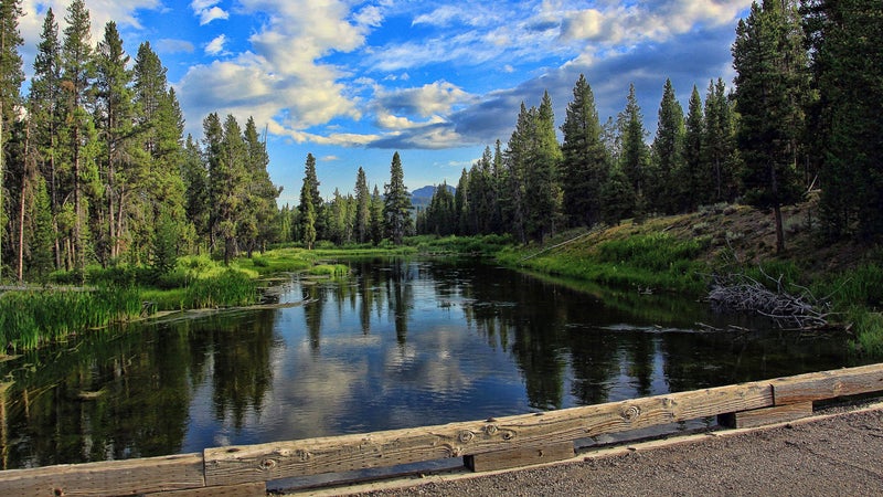
The 25 Best Runs in the World
Epic ultras in the Alps. An urban loop in running's most beloved city. High desert treks through the American Southwest. These are without a doubt the best runs on the planet.
New perk: Easily find new routes and hidden gems, upcoming running events, and more near you. Your weekly Local Running Newsletter has everything you need to lace up! .
Humans were born to run. It’s literally one of the things . But beyond its health and mental benefits, what keeps us coming back is the sheer variety of routes out there waiting for us to lace up. And that’s what makes this list so special. Whether you’re looking for a quick urban jaunt or a 100-plus-mile big-mountain ultra, there’s a bucket-list run in this roundup that’s calling your name.��Is the list subjective? Sure. But as a professional travel writer and (sometimes masochistic) runner, I have a pretty good idea of what places belong below. To put this together, I relied on personal experience as well as recommendations from equally dedicated runner friends and colleagues.
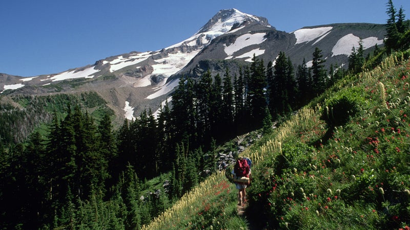
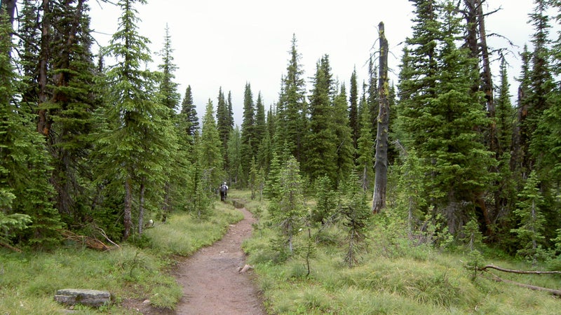
Timberline Trail
Mount Hood, Oregon
Distance: 38-mile loop
Elevation Gain: 9,000 feet
In the Pacific Northwest, there are multiple trails that circle the area’s volcanic giants, but the best may be ,��which loops 11,240-foot . was built by the Civilian Conservation��Corps in the 1930s and mostly stays around tree line. Views of the peak and its glaciers are nearly constant, and you’ll spot waterfalls, wildflowers, alpine meadows, and old-growth forests along the way. If you’re there in August, you’ll likely encounter thru-hikers on their way north to Washington on the Pacific Crest Trail. The route is well maintained and marked, but��fording the numerous rivers can be dangerous. When in doubt, don’t cross.
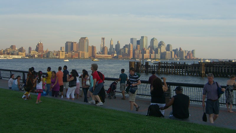
Hudson River Waterfront Walkway
Bayonne, New Jersey, to the George Washington Bridge
Distance: 18.5 miles one way
Elevation Gain: Flat
If you , it’s harder to see Manhattan. But to the west, on the New Jersey��side of the Hudson River, provides views of the city of 8.6 million and its endless sea of skyscrapers. Parts of the route have yet to be completed, but our favorite section is��the three-mile stretch that runs north from Morris Canal Park��to Pier A Park in Hoboken, passing the and Lefrak Point Lighthouse.��It’s best done just before sunset��as the city lights start to shine.
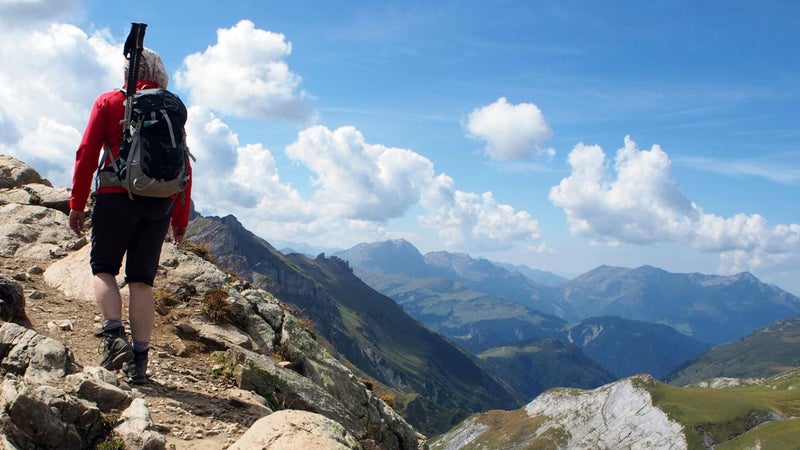
Tour du��Mont Blanc
Switzerland, Italy, France
Distance: 105-mile loop
Elevation Gain: 32,000 feet
This is perhaps over 100 miles out there. You could do it at all once, but that would be to deny yourself two��of the main joys of the Alps: the wine and cheese. Good thing you don’t have to choose between hedonism and masochism on this incredibly difficult and rugged route—you get both. So you’ll be free to run from hut to hut over stunning mountainside trails through France, Italy, and Switzerland, knowing that after��gaining between 3,000 and 5,000 feet of elevation each day,��you’ll be greeted��with delicious libations.��Or really and hike it instead.
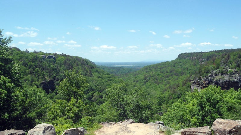
Lake Ouachita Vista Trail
Mountain Pine, Arkansas
Distance: 38.3 miles one way
Elevation Gain: 3,683 feet
, which was built over the past 10 to 15 years, curves through the Ouachita National Forest’s rolling mountain hills and stands of hardwood and pine. Like the name suggests, it also opens up to views of the deep-blue lake. In the summer, you’ll find wildflowers, and in autumn, the leaves turn to pleasing oranges and reds. Runners will top out��1,000 feet above the lake on��Hickory Nut Mountain and in the trail’s eastern section. Pro tip: the western end of the trail is in a dry county, so keep that in mind if you’re keen on a postrun beer.
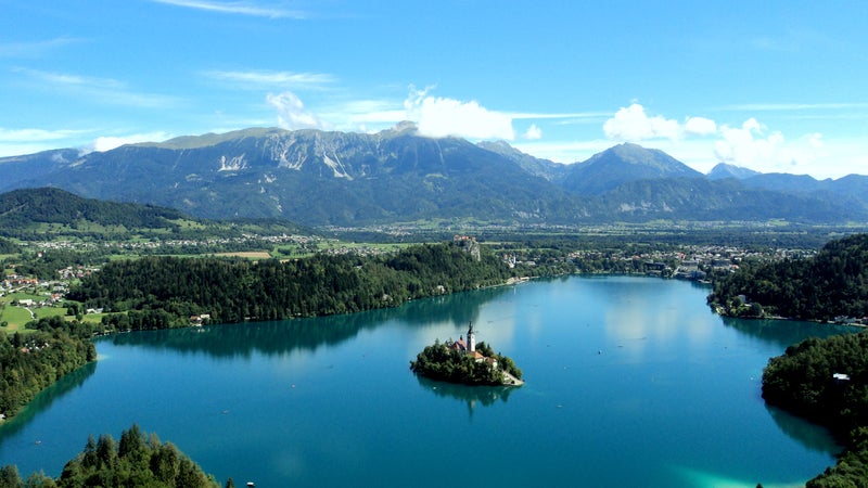
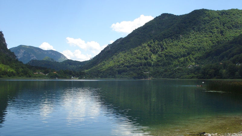
Lake Bled Loop
Bled, Slovenia
Distance: 3.7-mile loop
Elevation Gain: Flat
Bled, , looks more apt to grace the pages of a fairy tale than exist in reality. It��and its castle sit right on the bucolic turquoise lake, and there’s even an island in the middle that’s home to��a church only accessible by boat. hugs the tree-lined lakeshore, passing beaches for swimming and waterfront restaurants for refueling. Extend your run by heading up one of the many trails that lead��into the hills.
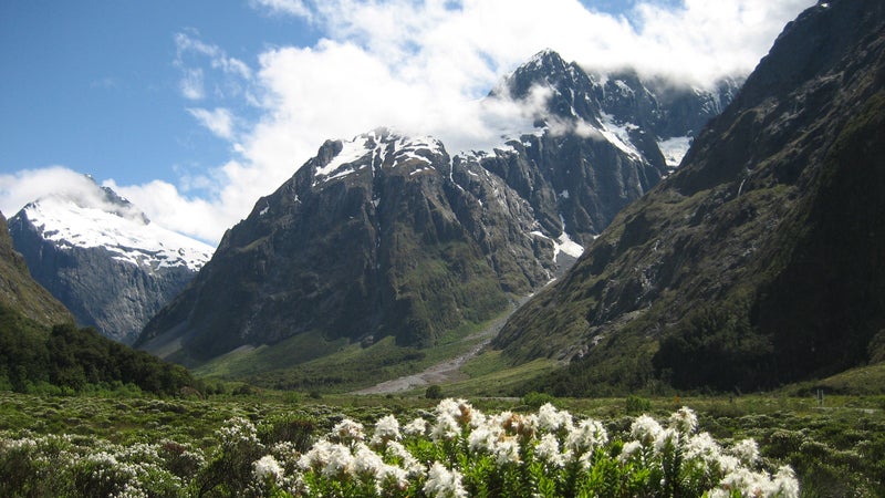
Kepler Track
Fiordland National Park, New Zealand
Distance: 36.7-mile loop
Elevation Gain: 6,388 feet
Located on New Zealand’s South Island in famed , provides a healthy dose of mileage��across alpine ridgelines, through forest, and alongside tranquil, expansive lakes. Expect a well-maintained and easy-to-follow path that changes from gravel to rock and dirt. Huts, complete with bunks and mattresses, can be booked along the way if you’d prefer to linger over the views of ��and����or swim the route’s��various lakes and beaches.�� are required, and the trail makes for an amazing four-day thru-hike.
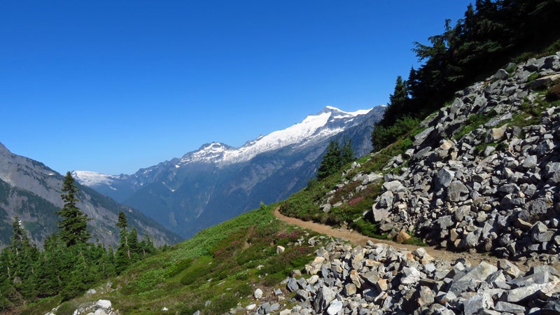
Copper Ridge Loop
North Cascades National Park, Washington
Distance: 34-mile loop
Elevation Gain: 8,600 feet
In 1968, a nearly century-long effort to designate this rugged region as a was finally realized with President John F. Kennedy’s signature. It’s easy to see why it’s worthy of federal protection when you’re on . is about 3.5 hours from Seattle, and the singletrack route winds 34 miles through dense forest, across ridgelines, and through a lush river valley. Vistas of heavily glaciated Mount��Shuksan, Mount��Baker, and the remote Pickett Range abound. Expect jagged summits coated in sprawling glaciers, evergreen trees, sparkling alpine lakes, and fields of wildflowers. Bonus:��you’ll��even cross the Chilliwack River via two-seater cable car.
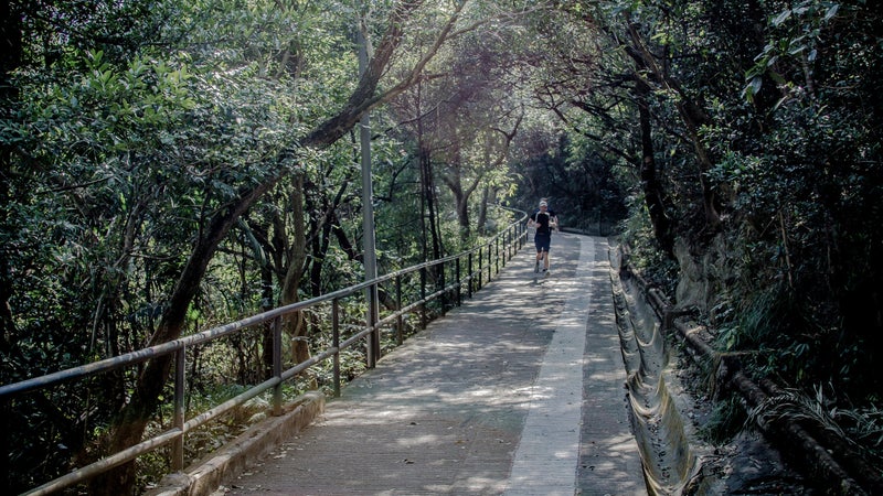
Hong Kong Trail
Victoria Peak, Hong Kong
Distance: 31 miles one way
Elevation Gain: 4,300 feet
runs 31 miles from Victoria Peak, the highest point on , to Tai Long Wan��(which translates to Big Wave Bay) and consists of eight different sections. The first two are partially paved, but later sections are slightly more rugged. The paths are shaded by a canopy of trees, so it’s a great place for avoiding the sun during warmer months. From Victoria Peak, you can soak up��panoramas of Victoria Harbor and Kowloon, the mainland portion of the city. Along the way, you’ll find diverse plant life, reservoirs, waterfalls, and stunning views. The terminus of the trail sports nice views of its own as well as a beach.
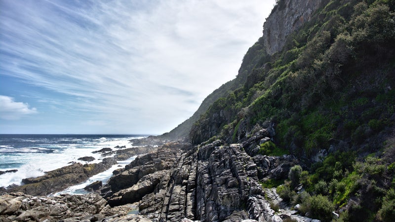
Otter Trail
Garden Route National Park, South Africa
Distance: 26 miles one way
Elevation Gain: 9,737 feet
This is the most exclusive trail on our list. Located in , the area is strictly protected, and people often have to wait a year to reserve their spot��as only 12 people can start the hike each day. Which means if you’re lucky enough to get a chance to , you won’t find any crowds. The path passes through diverse landscapes that include evergreen forests, waterfalls, rivers, a rugged coastline, pristine beaches, and an array of flora and fauna. Want to race it?��The is held in October.
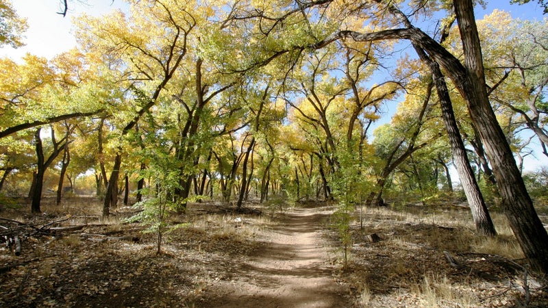
Bosque Trail
Albuquerque, New Mexico
Distance: 16 miles one way
Elevation Gain: 75 feet
is a paved path that flanks the Rio Grande in��a lush river valley . To the east, the Sandia Mountains dominate the horizon at over 10,000 feet. To the south, the skyline of New Mexico’s biggest city cuts the sky. This run is best done on crisp fall mornings,��as the cottonwood trees start to yellow and colorful hot-air balloons rise above you. The flat trail allows runners of all skill levels to get into an easy rhythm while enjoying views of nature.
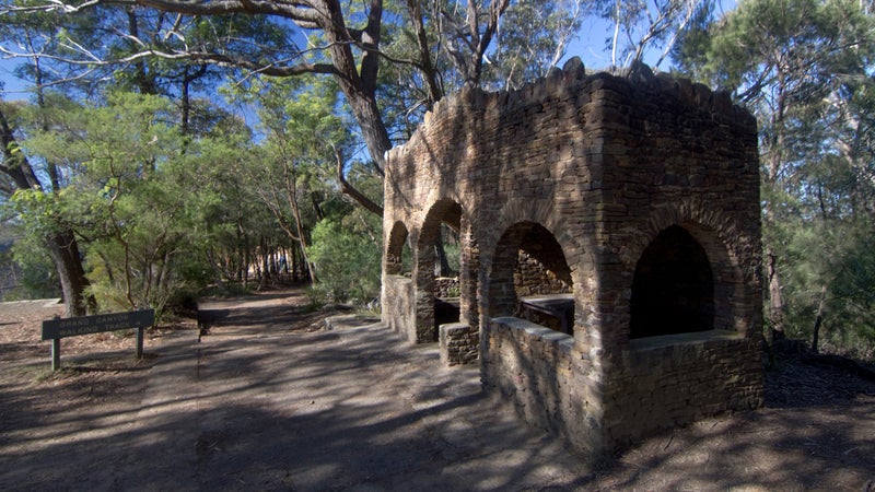
Grand Canyon Walk
Greater Blue Mountains, Australia
Distance: 4-mile loop
Elevation Gain: 1,020 feet
In 2000, and their dense forest of eucalyptus trees became a . , opened in 1907,��is one of the more popular trails to explore the region, with views��of the mountains and across the sprawling Grose Valley. You’ll run through lush rainforests and��past sandstone walls, overhanging rock, caves, and waterfalls.
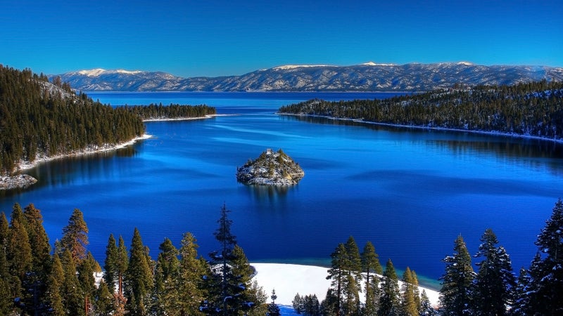
Tahoe Rim Trail
Tahoe City, California
Distance: 170-mile loop
Elevation Gain: 27,916 feet
circles the sparkling blue waters of��expansive ��and offers stunning mountain vistas. The route crosses��both the Sierra Nevada and the Carson Range, through forests of ponderosa pine, past smaller lakes, and across ridgelines with sweeping views. Many runners start from Tahoe City and head clockwise, finishing on the section that cuts through the Desolation Wilderness. , so you’ll want to plan ahead. And if you’d rather tackle the footpath in a more organized fashion, the are held every July.

Luxembourg Gardens
Paris, France
Distance: 1.3-mile loop
Elevation Gain: Flat
, just a mile from the banks of the Seine River and Notre Dame Cathedral, offer a tranquil reprieve in . The��1.3–mile loop��around the perimeter of the gardens is the shortest route on our list, but you’d be remiss not to zigzag through the paths bisecting the grounds. Created in 1612 by Marie de Medici, who was married to King Henry IV, the attraction is��also home to some 100 statues, fountains, perfect grass, beautiful flowers, and the grand Luxembourg Palace.
Carthew-Alderson Trail
Waterton Lakes National Park, Canada
Distance: 12 miles one way
Elevation Gain: 1,438 feet
and make your way 12 miles to , which sits on the tree-lined coast of Waterton Lake—at 444 feet, the deepest body of water in the Canadian Rockies.��Switchbacks climb high into the hills above lush valleys surrounded by snow-capped mountains, and you’ll earn views of turquoise lakes, steep peaks, and alpine meadows. If you know where to look, you can even spy points within��, just across the international border. Far from any major population center, this��run is seldom crowded.
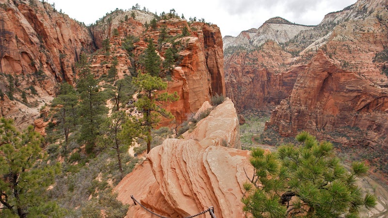
Zion Traverse
Zion National Park, Utah
Distance: 48.8 miles one way
Elevation Gain: 6,292
is a long tour through an incredibly diverse landscape. The route cuts through scenic canyons tucked between towering 2,000-foot sandstone cliffs, and you’ll get to enjoy��slopes of bright-green pine and juniper popping against a backdrop of red and brown rock, hanging gardens, waterfalls, and unique sections of exposed trail. As the run��drops from nearly 9,000 feet to less than 4,000 feet, it’s interesting to watch the topography change from a lush riparian environment to sandy desert. Careful planning is necessary in order to account for heat and water resources. And .
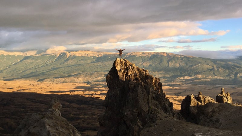
Lagunas Altas Loop Trail
Patagonia Park, Chile
Distance: 14-mile loop
Elevation Gain: 4,160 feet
Created with the help of Kristine Tompkins, CEO of Patagonia, and , who cofounded the North Face, ��protects over two million acres of land. The in t starts at West Winds Campground, which is not far from park headquarters, and��provides sweeping views of the area’s mountains, the Northern Patagonian Ice Field, alpine lakes, dense forest, and rocky outcroppings. Look for deer, pumas, and condors along the way. The run is worth a trip by itself, but it also makes for a great pit stop on the Carretera Austral, a scenic road that’s long drawn bikers and road-trippers.
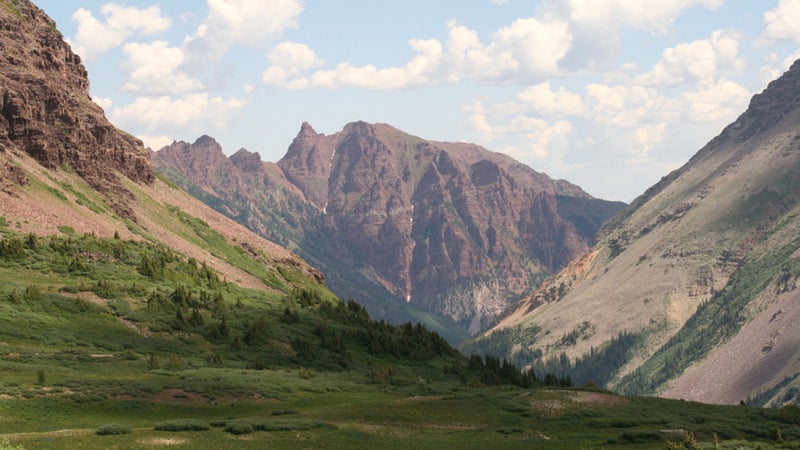
Four Pass Loop
Aspen, Colorado
Distance: 28-mile loop
Elevation Gain: 7,327 feet
The Forest Service calls , which , an “ambitious backpacking trip.” It’s an even more��ambitious one-day run. But for those ready for the lung-squeezing altitude, it also features a series of incredibly beautiful views through . The easy-to-follow trail passes alpine lakes, through fields of wildflowers and aspen trees, and offers vistas��of the severe Maroon Peaks and thundering waterfalls, including one that tops out at nearly 200 feet. Make sure to bring adequate layers for the passes, where a sunny day can quickly turn to snow, even in the summer.
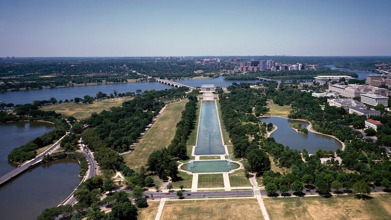
Potomac River to the National Mall
Washington, D.C.
Distance: 4.8 miles one way
Elevation Gain: Flat
on the southern portion of the , and follow the canal’s former towpath southeast past rows of Colonial-style homes to . From there, drop down to the northern bank of the Potomac River, follow it��past the stunning Kennedy Center for the Performing Arts, and head up the back side of the Lincoln Memorial. Continue past the memorial’s��reflecting pool��and toward the 555-foot-tall . ends at the U.S. Capitol, which is sure to stoke your patriotism if it hasn’t been already. The run is best done before the city wakes up: sunrise is one of the only times the area is quiet.

Rim-to-Rim-to-Rim
Grand Canyon National Park, Arizona
Distance: 48.8 miles round-trip
Elevation Gain: 11,400 feet
The is one of the most spectacular ways to . You stand at its edge, staring down into the belly of the earth, before dropping 5,000 feet to the bottom to explore the changing landscape in detail. It should come as no surprise that this nearly 50-mile day mainly consists of either climbing up or going down, with a brief respite near the Colorado River. That’s one reason it’s a testpiece for elite runners trying to set FKTs, but the trail is equally remarkable for the rest of us mortals. It’s one of the best self-propelled geology tours there is.
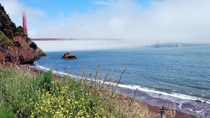
Coastal Trail
Marin Headlands, California
Distance: 5.9 miles one way
Elevation Gain: 1,750 feet
are right across from and home to miles of fire roads and singletrack��through hills of tall grass, past beaches, and up to lookouts with prime views of the city and the Golden Gate Bridge. It’s hard to go wrong, and you can easily link trails together to craft whatever kind of workout you’re looking for. Our favorite option? Hopping on at Rodeo Beach and taking it up into the hills along the Pacific��into the Tennessee Valley, ending at .
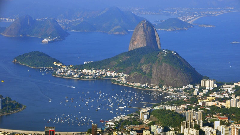
Transcarioca Trail
Rio de Janeiro
Distance: 111 miles one way
Elevation Gain: 42,650 feet
In 1995, Pedro da Cunha e Menezes, a Brazilian hiker, visited the Appalachian Trail and was inspired to create a long-distance trail . He had a lot of experience hiking��paths in the area, and his work as a flight attendant helped him scout it from the air. Twenty years later, was born. The trail starts in��the city near the��iconic Sugarloaf Mountain��and continues on past lagoons, waterfalls, and jungles��through six different protected areas.
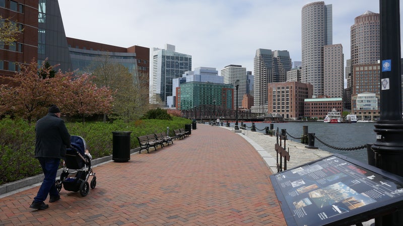
Charles River Path
Boston
Distance: 8-mile loop
Elevation Gain: Flat
There are few running towns as storied as : it has��hosted the legendary Boston Marathon since 1897, after all. Every April, elite athletes and amateurs��alike flock to the city to run the course, but ,��which divides Boston from Cambridge, may be for nonsuperhumans. The tour starts from Science Park in Boston and runs to Harvard University before crossing the bridge at JFK Street and heading back along the other side of the waterway. Enjoy the grassy riverbanks, and watch boats cut across the smooth water.
Prenj Massif to Vran Mountain on the Via Dinarica
Bosnia and Herzegovina
Distance: 40 miles one way
Elevation Gain: Flat
The spans 1,200 miles and eight countries across the . The result of a collaborative effort to promote tourism, the route passes through tiny villages and��open meadows, past shark-fin ridges, and down the Adriatic coast. It would be incredible to do the trail in its entirety via a longer thru-run, but it’s ripe for picking off prime sections one by one. The road to Prenj Massif is a great place to start. The peak itself rises over 7,000 feet, a jagged limestone gem for area mountaineers, and the landscape between Prenj and Vran displays some of the best of Bosnia’s rugged high alpine. But beware: the route is lined with forests and signs warning people not to enter due to unexploded land mines, relics from the region’s wartime past.
Teton Crest Trail
Jackson, Wyoming
Distance: 39 miles one way
Elevation Gain: 8,061 feet
Running deep ��will allow you to both leave the summer crowds behind and see the mountain range from a less common perspective. (depending on where you start) rarely drop��below 8,000 feet and have the same amount of elevation gain. The route passes through , , and the and . You can expect staggering peaks, meadows, glacier-carved canyons, alpine lakes, mountain passes, and a section of particularly amazing��views��from the iconic Death Canyon Shelf. August is great for its relative lack of mosquitoes and abundance of wildflowers.��And to really soak in the route’s dramatic beauty, the trail also makes for a great, quick thru-hike.
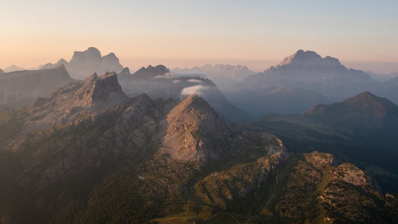
Alta Via 1
The Dolomites, Italy
Distance: 75 miles one way
Elevation Gain: 22,000 feet
On the other end of the Italian Alps from Mont Blanc you’ll find the equally stunning and the , one of Italy’s famed,��numbered high-Alpine footpaths. The route starts on the shores of Lago di Braies, a stunning mountain lake in South Tyrol, and finishes in��the town of Belluno, 60 miles north of Venice. As you can gather from the elevation gain, the trail has many ups and downs along the way, but you don’t have to do it all in one go: there are a number of ��(backcountry huts)��to rest your weary muscles.