

What’s the worst situation your phone’s GPS has ever led you into? Maybe you wasted an hour looking for a long-closed restaurant, or ended up taking a dusty detour on a gravel farm road. Whatever it was, we’re willing to bet it wasn’t as bad as the hiker who needed a helicopter rescue in British Columbia last week after he apparently followed a non-existent trail on Google Maps.
North Shore Rescue (NSR) , north of Vancouver, in a trailless area criss-crossed by cliff bands. A helicopter hoisted two rescuers down to the heavily-forested mountainside below the hiker’s suspected location. The team then moved up the slope on belay until they located the missing individual and brought him back down, where the helicopter retrieved all three.
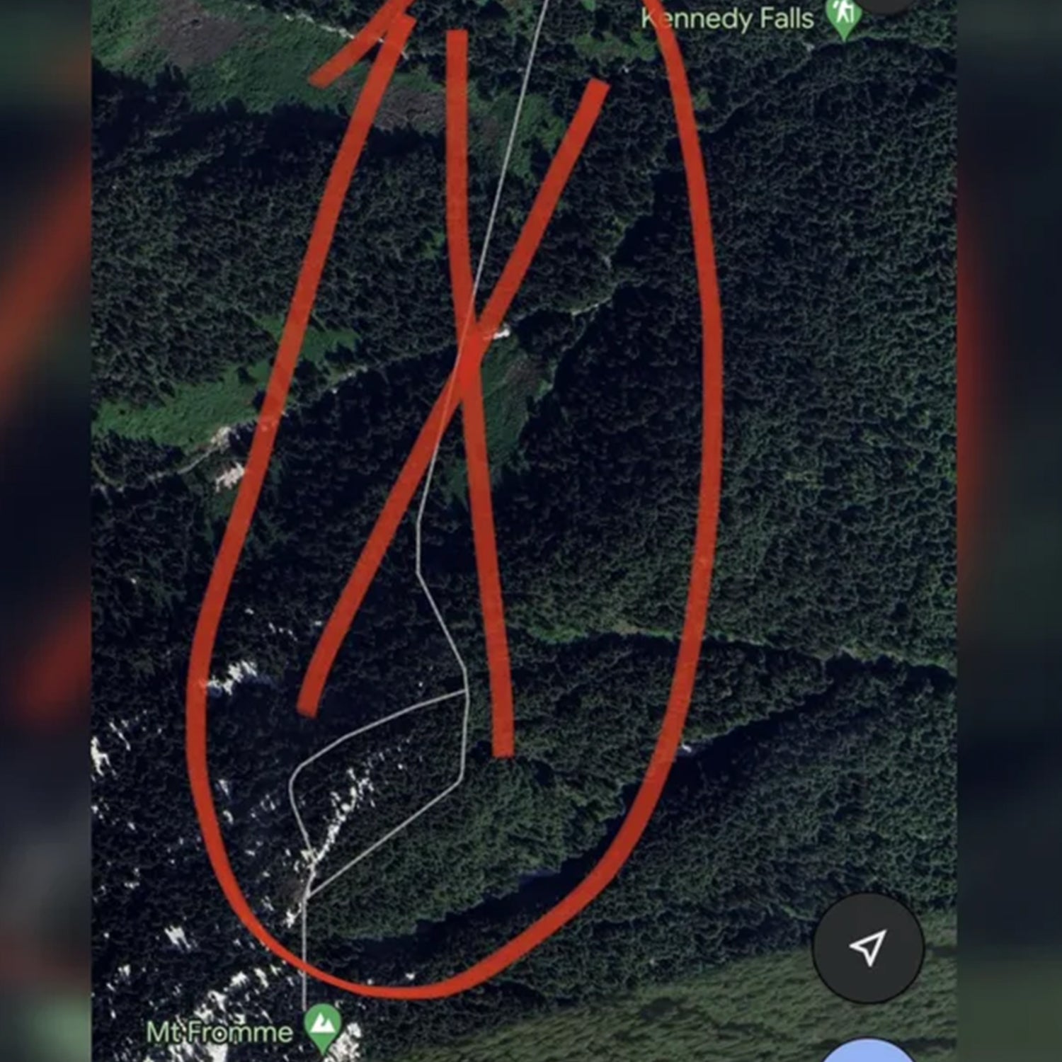
In a Facebook post about the rescue, NSR shared a picture of the phantom trail the hiker had attempted to follow from the Kennedy Falls area to the summit of the peak. According to the group, the hiker was to require rescue from Mt. Fromme after following the “trail.” (A third hiker died in the area in 2021, though there’s no evidence to suggest Google Maps played a part in that incident.) While it initially said that Google had not responded to their requests to remove the nonexistent trail, the team wrote in an update on Monday that the path no longer appeared in the app.
Google has tangled with outdoor groups over how it displays trails and hiking objectives before. In 2021, Mountaineering Scotland would lead them to the closest parking lot to the summit, rather than the visitor’s center, where most hikers leave from to make the eight-hour round trip. From the lot, a dotted line appeared to lead straight up the steep and cliff-guarded mountainside—a difficult and dangerous route for even advanced hikers. (Google, which said that the dotted line was supposed to be an abstraction of the distance to the summit, not an actual route, eventually changed the directions in response.)
The danger from phantom GPS trails isn’t just to people, but to the environment as well. In a 2021 interview with Boston NPR affiliate , hiker and writer Wesley Trimble recalled one instance in which one app displayed a non-existent connector trail between two segments of path; in reality, the track ran up a blank, 35-degree hillside. Enough hikers following that path would eventually beat a trail into the slope, leading to erosion and killing fragile plant life.
In response to last week’s rescue in British Columbia, North Shore Rescue urged hikers to use either a paper map or a purpose-built hiking app like or CalTopo rather than an app made for on-road urban navigation like Google Maps. (Editor’s note: Backpacker’s parent company, �����ԹϺ��� Interactive Media, owns Gaia, and �����ԹϺ���+ members get a premium subscription to the app.) Hikers who do choose to navigate by phone should always carry a spare battery, the group noted.
It’s easy to point to the phone as the problem, and indeed, “always carry a paper map and compass” has become a common refrain among some hikers every time one of us follows our GPS into trouble. But as any of us who started hiking in the pre-smartphone era know, navigating the old-school way isn’t a prophylactic against wandering off trail. For starters, —many hikers today, especially younger hikers, likely couldn’t triangulate their location from known landmarks if their lives depended on it—and is next-to-impossible in thick forest or under heavy cloud cover, both of which last week’s rescue contended with.
A better idea: Pack your situational awareness. Whether you choose to navigate with a paper map, an app, or a dedicated device, put unknown trails to the sniff test: If they peter out into forest or unmarked desert, or you find yourself unexpectedly scrambling up steep or loose terrain, stop. Instead of forging ahead, check that map, and consider whether it’s time to admit you’ve gotten off-course and turn around. It could save you from an unexpected helicopter ride, a long fall, or a cold, lonely night in the woods.