��The Colorado Trail race is happening right now and thanks to Tucson resident, Scott Morris, we can all become blue-dot junkies.
Scott is the owner of Topofusion and Trackleaders. His GPS software lets you know where you're going, and where you've been, showing your progress on a map with blue dots. Computer Science and really long bike rides–I don't think it gets any better then that.
You’ve raced CTR, Grand Loop and are the promoter and former record holder of��AZT 300.
Yep, or you can call it the Arizona Trail Race. ��There’s a 750 mile version (Mexico->Utah) and 300 mile option as well.
A PhD in computer science and you’ve never held a desk job. Very nice.��How do you sustain your lifestyle?
Frugal living, I guess? ��Too busy riding or planning the next ride to be out spending money on stuff.
You currently have 2 products out:�� and��h You also host a site which is a community website with forums, routes, gear info, etc all about bikepacking:�� ��and you have a blog:����You are taking over the internet!
What can I say? ��I'm obsessed. ��If only there were four of me so I could spend as much time as I'd like on each project.
In a nut shell, what does each product do?
TopoFusion is my bread and butter. ��It’s a desktop mapping application designed for mountain bikers, hikers, runners and other outdoor types. ��It talks to Garmin GPS units and provides all sorts of visualization, analysis and planning tools.
Trackleaders is newer, and is web based event tracking software. ��It’s based on SPOT (http://findmespot.com) satellite trackers. ��It’s realtime tracking, making it ideal for ultra distance stuff like bikepacking races, which are otherwise impossible to spectate.
Are they all free?
TopoFusion has a free demo version (http://topofusion.com/download.php) that people can try for as long as they wish. ��Registering the software costs $69.95.
Trackleaders is free for spectators, but we charge a tracking fee for events (CTR and other free bikepacking events are an exception here — we don’t charge organizers anything).
Are you partnered with anyone for these products?
One thing I’m super excited about right now is TopoFusion’s partnership with the folks at myTopo in Billings, Montana. ��TopoFusion v4.0 came out a month ago and provides access to myTopo’s beautiful set of topo maps for the US.
Matthew Lee is my parter in Trackleaders and has been the major force behind the ideas and dream of online event tracking. ��I’m lucky he chose me to help with the software end of things.
Do any of them work on a Mac?
TopoFusion is Windoze-only, sadly. ��I get many requests for a Mac version, so who knows, it may happen.��Trackleaders is all web based, so it works on everything.
What prompted you to combine your two passions: computer science and��insanely long bike rides?
It just seemed natural. ��Computers by themselves are only interesting for so long. ��I’m really lucky that I’ve been able to add cycling and other outdoor pursuits into the mix. ��TopoFusion inspires more riding, and it works the other way too, when a new challenge for riding drives cool features in the software.
Do you have plans to branch out of bike packing and into moutaineering?
I’m too much of a coward personally, but we would love to track the big mountains!
The Colorado Trail Race is going on right now.��You added a new Doppler radar overlay��so we can see the weather racers��are encountering.
Yep! ��It currently shows that *everyone* is getting wet out there. You can see them
People are really jazzed about the radar feature, but I really added it for selfish reasons. ��You see, I wimped out on racing this year (ankle still not healed from an injury), so I have to try to convince myself that I made a good decision by seeing just how bad the weather is out there. So far it’s working out well for me. ��🙂
Any more cool stuff like this coming out?
Lot’s of cool stuff on the drawing board, hopefully some of which will come out during this year’s CTR. Right now I’m working on a way to graphically display lead changes.
How big is the tracker and how much does it weigh?
The SPOT2 devices area bit bigger than a cell phone and weigh about five ounces.
Do atmospheric particles ever effect the tracking accuracy from the��satellite?
Sometimes, but my experience with SPOT trackers is that they are very reliable. ��We’ve tracked everything from dog sled races in the Yukon to sailing races on the Florida coast.
These are all great features for the armchair CTR racer. Do people get��addicted to following the race?
Oh yes, they call themselves “blue dot junkies” (due to the blue paddle icons on the map). ��It’s really cool to see people get inspired by following the riders, day after day, then see them sign up for the event next year. ��I love that aspect of this stuff. ��If the tracking gets just one person to ride a little longer, a little higher or a little more often, I say it’s a success!
What were some of the biggest mistakes you make on some of these long trips?
I made every mistake in the book, and continue to do so. ��The most memorable ones had to do with running out of stuff — food, water, daylight, trail or all of the above!
What were some really bright ideas?
Learning to do the map work *before* a ride, on the computer, was a huge revelation to me. ��Having a well researched GPS line to follow has made exploring 300+ mile routes possible without carrying hundreds of maps. ��I had to write my own software to do this the way I wanted though…
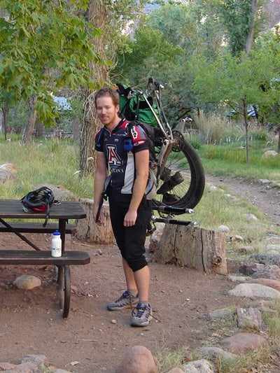
Is it true you have to carry your bike across the Grand Canyon for AZT? Nowheels on the dirt? How long did that portion take?
If you’re going fast you try to carry your bike across in a day. ��It was probably the hardest thing I’ve ever done, period. ��Racing 600 miles to the south rim had pretty much drained my legs of all strength, and I was reduced to tiny baby steps before I made it out of that ‘big ditch.’
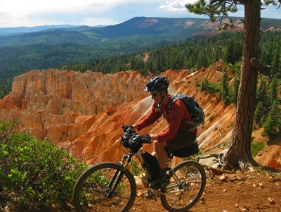
Tell me why I should want to do the AZT.
Where to start? ��The diversity in Arizona is hard to match. ��There are so many varieties of ‘desert’ here, and then we have sky islands full of trees, and the Grand Canyon. ��The AZT covers it all.
What is the longest bike packing trip you’ve done?
I pedaled the Great Divide Mountain Bike Route with my fiance, Paula Morrison. ��It’s 2,500 miles. ��Paula is a 3 time Olympic Marathon Trials qualifier, but she’s not a cyclist! ��She learned fast!
When you are bike packing, where does most of your food come from? Gas��station snacks? Grocery stores?
Gas station junk supplemented by real meals in cafes, burrito joints and restaurants. ��You can only subsist on twizzlers for so long (though you may be surprised…)
How do you keep yourself clean?
You don’t. ��You just keep riding. ��I never got a room during the Colorado Trail Race last year, but I would have loved to grab a shower somewhere.
Clearly you are not carrying all the food with you.��What calorie dense foods do you go after?
Salami and parmesan cheese are a favorite, though the good stuff is hard to find outside of large towns.
Have you ever run out of food and had to eat ANYTHING in an emergency?
I just keep riding, and keep bonking. ��Bonking is a way of life when bikepack racing.
What was your most life threatening situation on any given ride?
I was once tracked by a mountain lion, at night, while racing the Arizona Trail. ��I kept seeing the same pair of glowing eyes every time I checked the cliffs above me. ��The cat knew right where I was headed since I was riding up a narrow box canyon, but fortunately it decided not to pounce on me.