What It’s Like to Be an Aerial �����ԹϺ��� Photographer

Garrett Fisher’s day job is executive director of the Institute for Economic Innovation, a think tank he founded, but he spends nearly as many hours on his passion project: flying his blue and yellow Piper PA-11 Cub Special plane over mountains, glaciers, and grasslands, cracking open the pilot-side window, reaching his arm out with Canon EOS Rebel SL1 in hand, and snapping some of the most beautiful aerial landscape shots we’ve seen. The plane is nearly 70 years old, has no heating system, and flies slowly, all of which make for an uncomfortable ride in varied terrain and bad weather. “I usually go alone,” Fisher says. “People always end up puking.”
Fisher, who’s been flying since he was 16, scouts locations by exploring random points of interest on Google Earth or a U.S. Geological Survey map. Then he’ll spend up to 13 hours a day in the air (with fuel stops every three hours), focusing on capturing photos that serve as art and resource. His photos can serve as message (he’s shot receding glaciers at Glacier National Park, among others) or reference (he’ll overlay a composite image of every single 14er in Colorado with a map, for example, which is useful as a “mountaintop-perspective” guide for hikers). “I’m looking for an interesting integration of ground to horizon to sky,” he says. In February, he moved from Alpine, Wyoming, to Germany (“maybe for good”) and will put his energy into capturing Europe from the air. We asked for the stories behind some of his favorite—or most hard-won—images so far.
Photo: Grand Prismatic Spring, Yellowstone
“For hot spring imagery, the angle of photography completely changes. Instead of trying to tie sky, texture, and land into a subject, I am trying to peer into the heart of the hot spring, cutting through steam and reflections on the water, isolating everything else out of the image. It is a dance requiring a zoom lens and about six passes over the area to achieve a suitable focus and angle.”
“I call it ‘Mr. Toad’s Wild Ride:’ Where winds come over a mountain range and descend on the east side into sizable plains or desert areas, the turbulence increases massively. The Bighorn Basin is in the upper right of the image, a veritable vacuum sucking the winds over these peaks and giving me one crazy ride. Here’s what I have to do when I hit a rotating column of horizontal air like this: one minute, I’m ascending with no choice, idle the plane in response, and go up like an elevator. Things quiet down, I add power, and then bam! I hit the descending air and at full power, I am descending. Rinse and repeat until I can find a way out of it.”
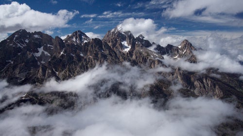
![“This was the only time that I have been unable to outclimb downdrafts [air currents] and had to abort for safety reasons. In the hurried escape to safer areas, I encountered the most severe turbulence of my flying career at 11,000 feet in these foothills. Take your worst turbulence experience in an airliner and make it three to five times worse. As sudden harsh bodies of air slammed against the airplane, I wondered if I’d stay in one piece. I later learned that some of the worst turbulence can be found 10 to 30 miles from the terrain that causes it.”](https://cdn.outsideonline.com/wp-content/uploads/2016/03/11/san-juan-mountains-garrett-fisher.jpg?width=500&enable=upscale)
“This was the only time that I have been unable to outclimb downdrafts [air currents] and had to abort for safety reasons. In the hurried escape to safer areas, I encountered the most severe turbulence of my flying career at 11,000 feet in these foothills. Take your worst turbulence experience in an airliner and make it three to five times worse. As sudden harsh bodies of air slammed against the airplane, I wondered if I’d stay in one piece. I later learned that some of the worst turbulence can be found 10 to 30 miles from the terrain that causes it.”
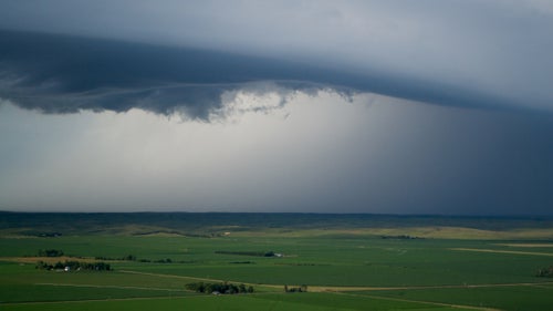
“Concluding the third day of a flight across the country in 2014, I encountered one of many lines of thunderstorms that cropped up over the central plains of Nebraska. I was attempting to land just ahead of the storm at Kearney, Nebraska, for the night, and realized that the storm was beating me to the airfield. I turned around, landed in Lexington, Nebraska, instead, and hurriedly tied the airplane down before the storm arrived.”
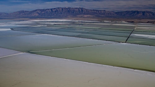
“Google Earth is one of my most valuable tools—I spend hours switching between satellite imagery and terrain mapping, looking for unusual features. These particular salt flats west of Ogden caught my eye. They’re a relatively small feature compared to the Salt Lake itself, which spans about 74 miles in length.”
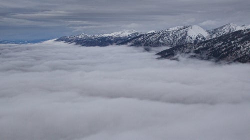
“I consider my home to be sailing above an overcast layer, detached entirely from the ground, floating above a sea of clouds. One of the problems with that idea is severe carburetor icing upon descending back to earth. If the right combination of moisture and temperature line up in the plane’s air intake system, it ices over and the engine quits. This is the closest I came to that happening—as I passed through the moisture layer in a hole in the clouds, the engine coughed and sputtered, but I was able to save the situation.”
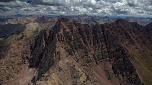
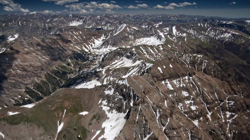
“Winds three miles from here were just fine. But crossing over Maroon Peak (14,156’), a sudden downdraft appeared. The safest option was to fly directly toward the peak and skim the ridge to the right to get back to safer territory. My guess was that the winds on the left area of this image were blowing straight down, while on the righthand ridge they would be turbulent, mixed up, and blowing upward at the lip of the ridge. The scary reality was that I could only confirm by flying right into it.”
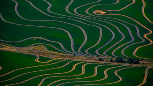
“Agriculture is nothing short of amazing when viewed from above, as farmers follow the curve and texture of land and water flow to maximize growth, painting a picture only viewable from the sky. I have cataloged fields all over the US for over five years, with a never-ending diversity of color and texture.”
“After a stupendous flight around the Tetons shrouded in clouds, I saw a massive thunderstorm had developed in Idaho, and my airplane was on a collision course with it, due to intersect by the time I got to my intended destination of Alpine, Wyoming. The storm was moving slightly faster than me. Using my fuel reserve, I diverted back to Jackson, Wyoming, landed, tied the airplane down, and waited two hours for the storm to blow over.”
“These sand hills feature in the Keystone Pipeline discussion since they’re an area of ecological fragility in central Nebraska, one of the states the pipeline would run through. While crossing the country in 2014, I came upon this area and found it to be incredibly sparsely populated, which is a risk in the event of engine troubles. In some places, homes are ten miles apart from each other. Luckily, nothing happened on this trip.”