
America’s national parks are known for their vast tracts of unspoiled wilderness, and we love celebrating the trails that take you deep into the backcountry��of these iconic landscapes. But sometimes, the best views in our national parks can be enjoyed from the comfort of your car. Here are the eight best national park scenic roads.
1. Trail Ridge Road, Rocky Mountain National Park, Colorado
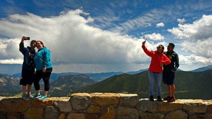
Trail Ridge Road carves a 48-mile path through the heart of Rocky Mountain National Park, connecting the gateway towns��of Estes Park and Grand Lake. It’s one of the highest paved roads in the country, with a peak elevation of 12,183 feet at the Gore Range Overlook. The two-lane blacktop is a stiff challenge for cyclists (I always see a few on this road when I’m in the park) as it climbs more than 4,000 feet in just 12 miles, but it’s a convenient way for the rest of us to enjoy a high alpine environment; roughly eight miles of the road cruises above tree line with expansive views in either direction. Given the altitude, snowfall means the road is typically only open from late May to early October. I drove the road in July with my family one year, and we marveled at the amount of snow that was still piled up at the pass.
Best View��
The Gore Range Overlook (at mile 19.3 if you’re coming from Estes Park) sits near the crest of the road with long range views to the west of the Never Summer Mountains. Gaze down from the parking lot and you’ll see small ponds scattered across the tundra. To the east, you can see Longs Peak, one of Colorado’s most famous 14ers.
Get Out of Your Car
If you drive the entire road, you’ll have more than a dozen opportunities for short hikes. Make sure you explore from the Alpine Visitor Center. It’s usually not as crowded as Alpine Ridge, which also begins at the visitor center, but takes you through the high alpine tundra with views of the Never Summer Mountains in the distance and the Cache de la Poudre River below. You’ll hit a forest of spruce and firs after two miles, which is where most people turn around. If you go all the way to Milner Pass, it’s an eight-mile out and back, dropping 1,000 feet on its way to the pass. Keep an eye out for pikas and marmots along the way.
Reservations
You need a to enter Rocky Mountain National Park during the summer, but if you’re only planning to stick to Trail Ridge Road and not visit the super popular Bear Lakes Corridor, then reservations are easier to get and only necessary between 9 and 2. So even if you don’t plan ahead, you could start your drive early and catch the sunrise, or start in the afternoon and enjoy the sunset.
2. Chain of Craters Road, Hawaii Volcanoes National Park, Hawaii��
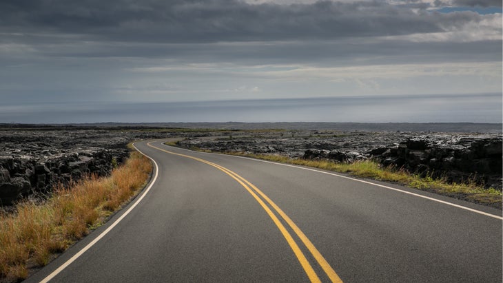
You should drive this road now, while you can, because there’s no guarantee that the pavement will exist in the future. Hawaii Volcanoes National Park, on the Big Island, encompasses several active volcanoes that have altered the landscape and the two-lane scenic highway multiple times in the last century. Currently, Chain of Craters Road is just shy of 19 miles long, traveling from the top of Kilauea Volcano to the Holei Sea Arch, which hangs over the Pacific Ocean. The road used to carry on past the arch, but that portion of the highway has been swallowed by lava. That’s what makes this road different from most others in the national park system; you get the opportunity to see the lava that created the Hawaiian islands up close and personal, as the road cruises by several active volcanic craters and the remnants of their outbursts.
Best View
Most of the pullouts along the road offer expansive views of lava fields in various stages of existence. The newer ones will be dark, rolling fields void of life, but the older lava flows will have vegetation and trees sprouting from the creases. The best view comes at the end of the road, when you can take a short walk to see the Holei Sea Arch, a tall, skinny window in a lava-rock cliff that formed over time as the Pacific Ocean slowly eroded the center of the rock.
Get Out of Your Car
There are a handful of hiking opportunities along the Chain of Craters Road. You can even hike what’s left of the former road beyond the current turn-around point at Holei Sea Arch. If you want a short hike, the .7-mile will take you on a boardwalk through an old lava field to a vast collection of petroglyphs that were carved into the lava more than 500 years ago.
Reservations
No reservations required. Entrance fee is $30 per vehicle.
3. Skyline Drive, Shenandoah National Park, Virginia��
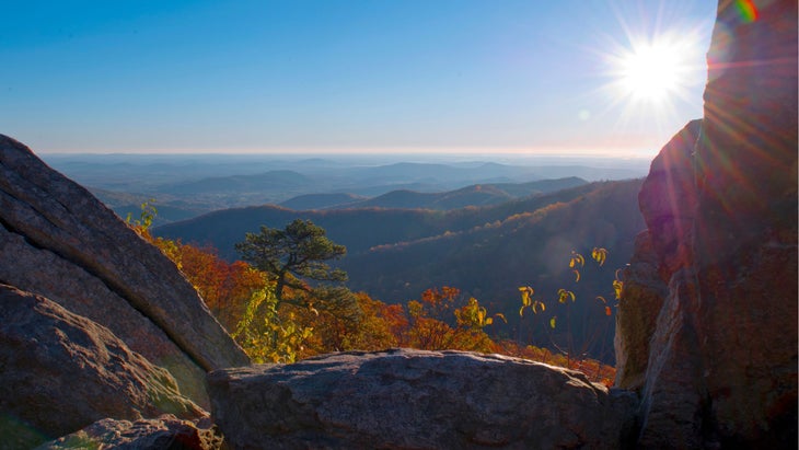
Skyline Drive runs 105 miles through the center of Shenandoah National Park, following the crest of the Blue Ridge Mountains. Consider this road a compressed version of the 469-mile Blue Ridge Parkway, which connects Shenandoah and Great Smoky Mountains National Parks. You can do the road in half a day, but a campground and at the halfway mark make this the perfect two-day adventure. The two-lane road crests at 3,680 feet and offers 75 pullouts with views that extend deep into the mountains and down to the Shenandoah Valley below. Timing your visit during the fall, when the hardwoods in the surrounding mountains are popping with color, makes Skyline Drive a bucket list experience. Biking Skyline from end to end is one of the most memorable centuries on the East Coast. The road is open year round, but will occasionally be closed during the winter because of snow. Check the before you start your trip.
Best View
There are overlooks every couple of miles along Skyline, but the views really stack up around the midpoint as the road reaches its highest elevations. Spitler Knob Overlook, at milepost 48.1, looks west, taking in the Shenandoah River below and the mountains that divide Virginia and West Virginia on the horizon. The sunset from here is stunning, too.
Get Out of Your Car
Head for the highest point in the park by hiking the to the 4,049-foot Hawksbill Summit. The 2.1-mile out and back begins at milepost 46.5, and ends at an observation platform on top of Hawksbill with a 360-degree view of the mountains and surrounding Piedmont.
Reservations
No reservations required. Entrance fee is $30 per vehicle.
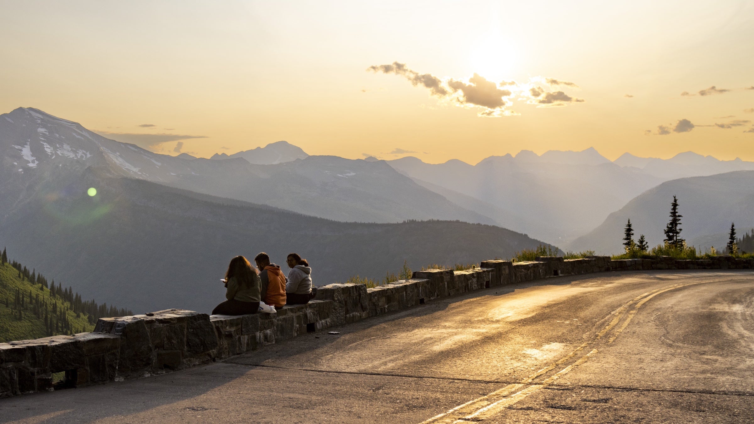
4. Going-to-the-Sun Road, Glacier National Park, Montana��
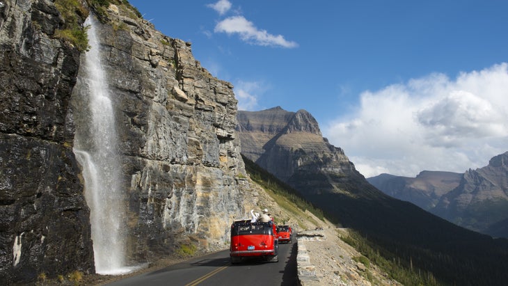
Yeah, this road is crowded, with parking lots along its path notoriously filling up by 10 A.M., but there’s a reason. Going-to-the-Sun Road, which bisects Glacier National Park while connecting the small gateway communities of West Glacier and St. Mary, might be the most scenic two-lane blacktop in the entire national park system. The 50-mile-long point to point highway delivers views of glaciated peaks, backcountry lakes, and the occasional waterfall, not to mention a great chance to see mountain goats. The road is an engineering feat as well—it took workers two decades to complete, with builders boring a number of tunnels into the cliffs. Going-to-the-Sun is only open to vehicles during the summer (typically from mid June to mid October), and there’s a brief hiker/biker season in May when human-powered traffic can access the road after it’s been plowed, but before the gates are open to cars.
Best View
Logan Pass is the most popular destination on the road, thanks to the visitor center and multiple trailheads there, but the Jackson Glacier Overlook has the sweetest view, as it gives you the best chance to see a glacier from the comfort of your car.
Get Out of Your Car
Going-to-the-Sun provides access to some of Glacier’s most iconic hikes and landscapes, so you could spend a full week knocking out trails without ever venturing beyond the road’s corridor. The 2.8-mile is a classic. You won’t have the trail to yourself (it’s one of the most popular hikes in the park) but the terrain you’ll experience is iconic Glacier, passing through meadows full of wildflowers in the summer before it��reaches a vantage point overlooking a high alpine lake nestled at the base of the granite-rimmed Bearhat Mountain. Turn back or double your mileage by following the trail to the edge of the lake itself.
Reservations
You need for the west side of Going-to-the-Sun Road from June 13 to September 28, between the hours of 7 A.M. and 3 P.M. Show up before or after that daily window if you want to drive the road but can’t score a reservation.
5. Crater Lake Rim Drive, Crater Lake National Park, Oregon��
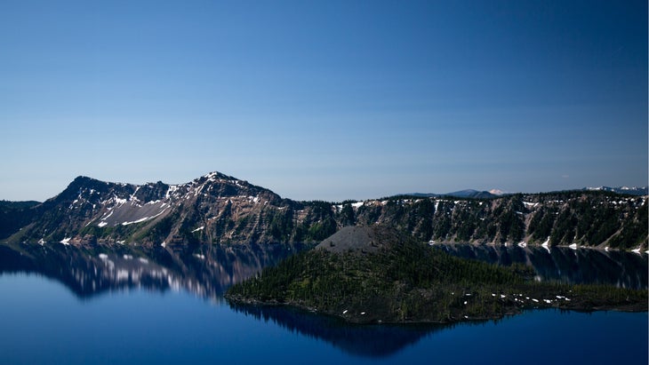
Crater Lake is a sight to behold. The 13,148-acre pool is the deepest lake in the United States, fed entirely by rain and snowmelt, and completely encompassed by the rim of a volcanic crater that was formed more than 7,000 years ago during an eruption. And it’s all set within the backdrop of Oregon’s Cascade Mountain Range. The 33-mile Rim Drive gives you a chance to see this lake and the crater from every angle as it forms a paved, two-lane path around the entire scene. There are 30 overlooks along the way, most of which offer a good view of the bright blue water and Wizard Island, a cinder cone island rising 775 feet above the surface of the lake. One of the coolest features of the road is that it was built to disappear into the landscape, so that you can’t see it as you’re looking out over the lake. Like many of the scenic park roads built in the 1920s and 30s, Rim Drive has tight curves and very little shoulder, so drive cautiously and watch out for cyclists. Crater Lake National Park gets an average of 41 feet of snow a year, so the road closes for winter, typically from November 1 to June 1.
Best View
Watchman Overlook, 6.5 miles from the visitor center, has one of the best views of the lake, particularly at sunset as it faces west. There’s also a short, mile-long Watchman Peak Trail that leads to a fire lookout tower with a 360-degree view of the lake, crater, and surrounding Cascade Mountains.
Get Out of the Car
You’ll get plenty of vista views of the lake from above, but is the only legal trail you can take down to the water’s edge. Find the trailhead on the East Rim Drive, 4.5 miles from where North Entrance Road intersects with West Rim Drive. It’s a steep, 1.1-mile sandy path from the road to the lake, dropping 700 feet before hitting the boulder-laden shore. Yes, you can take a dip in the water, but it’s cold, averaging 57 degrees in the summer.
Reservations
Crater Lake National Park doesn’t require reservations, but there is a $30 per vehicle entrance fee.
6. White Rim Road, Canyonlands National Park, Utah
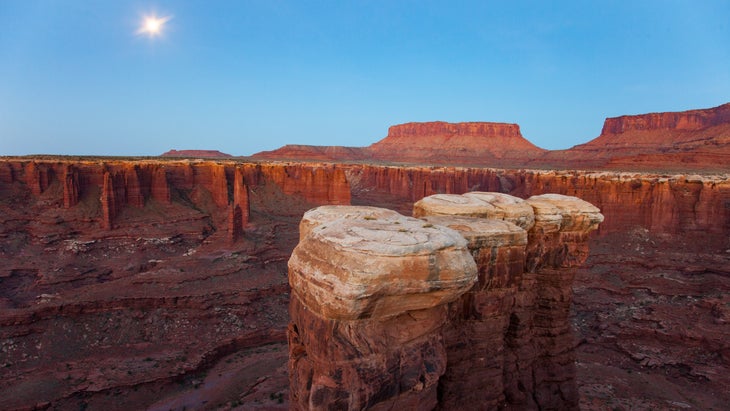
Canyonlands National Park’s White Rim Road isn’t like others on this list. Instead of a paved highway, is a 100-mile four-wheel drive route through the backcountry of Canyonlands, forming a loop around the park’s Island in the Sky district. It’s a two-day adventure, at minimum, requiring a high-clearance 4WD vehicle, as well as solid navigational and backcountry skills. But if you have the chops, there’s no better way to see the park than driving (or mountain biking, if you are so inclined) White Rim Road. Named for the pale slickrock that dominates much of the road’s terrain, the driving is a mix of sandy washes, rough rocky stretches and the aforementioned slickrock, which will occasionally take you to the edge of canyons. It’s a two-way road, but most people drive it clockwise. No matter which you go, it should only be attempted by overland veterans and always keep an eyee out for oncoming vehicles, hikers, and bikers. You’ll see towering buttes and monoliths as you drive along the Green River and switchback your way up and down the edges of deep gorges.
Best View
You’ll see some amazing scenery throughout the entirety of this road, but Monument Basin, roughly 30 miles into the drive if you’re moving clockwise, will give you the chance to park above beauitful canyons and snag an Instagram-worthy shot. Inside the basin below, you’ll see countless red sandstone spires rising from the valley floor.
Get Out of Your Car
The is a 3.4-mile out and back that leaves White Rim Road at mile 65 and meanders across the slickrock to the ruins of a stone structure built by the indigenous people that inhabited the area hundreds of years ago. From the ruin, you’ll have a grand view of the Green River below, with its lush banks standing in contrast to the red desert on either side.
Reservations
Any overnight along White Rim requires a . You can apply for a permit up to four months in advance of your trip ($36 permit fee, plus a $5 per person, per night camping fee), and designated campsites are scattered along the route.
7. Grand Loop, Yellowstone National Park, Wyoming, Montana and Idaho
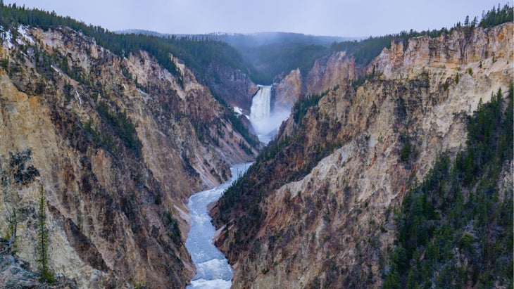
�۱�����Ƿɲ��ٴDzԱ�’s Grand Loop isn’t a single road, but a combination of two-lane roads that form a 145-mile figure eight through the heart of the park. You can do the entire figure eight or just tackle the upper or lower loop. If you attempt to drive the entire Grand Loop, it will be an all-day adventure. Some visitors even break it up into two full days, knocking up the Upper Loop on day one and Lower Loop on the second day. Drive the entire Grand Loop and you’ll hit most of the highlights in America’s oldest national park, with a chance to stop at geothermal wonders like Mammoth Hot Springs, Old Faithful, and Grand Prismatic Spring, while also being able to take quick detours to iconic landscapes, like the Grand Canyon of Yellowstone and the Lamar Valley, a broad grassland bisected by the Lamar River that attracts big game like bison and grizzly bears. If you have a snowmobile, you can explore the Grand Loop during winter, otherwise you’ll have to plan your trip between May and the end of October, when the road is cleared of snow. And be prepared for the occasional “bison jam,” when cars stop to watch the locals.
Best View
Artist Point Overlook, a detour off of the Upper Grand Loop on the South Rim Drive, provides the best view of the Grand Canyon of Yellowstone, which is 20 miles long and more than 1,000 feet deep. From this overlook, you get a great view of the canyon’s Lower Falls, a tumultuous 300-foot waterfall flanked by steep rock walls.
Get Out of Your Car
The seven-mile out and back from ��delivers views of the park’s most iconic landscapes, with vistas of the rim of the Grand Canyon of Yellowstone, Hayden Valley (a primo wildlife watching spot), and Yellowstone Lake. On a clear day from the lookout tower on top of Mount Washburn, you can see straight into the Grand Tetons, too. You’ll be following an old stage coach road on this hike, so there’s even a bit of Wild West culture thrown in for good measure.
Reservations
No vehicle reservations needed. Entrance fee is $35 per vehicle.
8. Park Loop Road, Acadia National Park, Maine
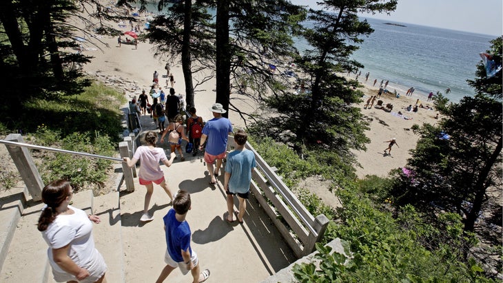
�������徱��’s Park Loop is the quintessential national park scenic drive: it’s short, gorgeous, and provides access to the park’s most popular destinations. The 27-mile one-way loop traverses the eastern flank of �������徱��’s Mount Desert Island skipping from freshwater ponds to beaches and cliffs, delivering some of Maine’s most iconic coastal views along the way. Acadia gets three million visitors a year, so the road gets congested, but you can still complete the loop in just a few hours. Take your time though, as Park Loop provides access to short trails and beaches that could keep you entertained for days. If you get a timed entry permit, you can tack on the three-mile too, which rises 1,530 feet straight out of the ocean, offering long range views of the Atlantic.
Best View
Dramatic views are a near constant along Park Loop, but Otter Cliff stands out above the rest, literally and figuratively. Otter Cliff is 110 feet tall, making it one of the tallest cliffs on the east coast. Spruce trees sprout from the top of the cliff, while a boulder-strewn beach can be seen below. Hit the cliff during the summer and there’s a good chance you’ll see multiple species of whales in the water.
Get Out of Your Car
Make a stop at Sand Beach, where you can take a swim if you’re brave enough to handle the Atlantic’s frigid temperatures, lounge and walk the , an easy stroll that accesses a variety of views of the Atlantic and Mount Desert Island’s coastline. The path will also take you to Thunder Hole, an inlet carved into the cliffs where incoming waves create a thunderous echo.
Reservations
You don’t need reservations to enter Acadia or drive the Park Loop, but you will need them if you want to drive the summit road to the top of . Entrance fee to the park is $35 per vehicle.
Graham Averill is �����ԹϺ��� magazine’s national park columnist. He loves a scenic road with an overlook as much as the next tourist and he recently wrote about the best road trips in the Southwest. He’s excited to plan his family’s next spring break trip, too.��