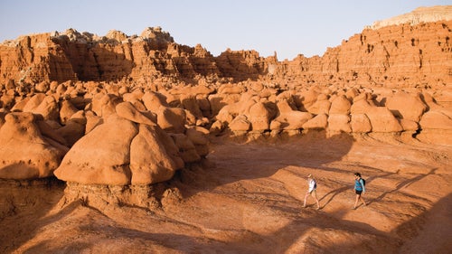
13 Lesser-Known Public Lands �����ԹϺ���s
It’s becoming harder to find a slice of nature all to yourself. But there are plenty of secluded sweet spots around the country if you know where to look. From national monuments and lakeshores to forests and scenic waterways, here are some stunning, uncrowded wildlands that are definitely worth exploring.
New perk: Easily find new routes and hidden gems, upcoming running events, and more near you. Your weekly Local Running Newsletter has everything you need to lace up! .
America has more than 828 million acres of public lands, an incredible boon to adventurers in every state. This month, when the crowds flock to the major national parks, we’ve got our eye on trips to 13 public lands worthy of explorations that feel truly wild and free. From caving, canoeing, and camping to mountain biking, birding, and swimming, you can relish these areas without pressure or reservations.
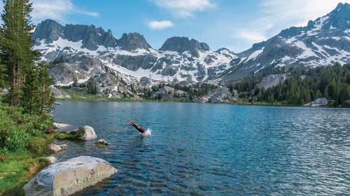
Ansel Adams Wilderness
Location: Straddling the Great Western Divide of the Sierra Nevada, California
Why we chose it: When summertime crowds make a beeline for Yosemite Valley, serious hikers, anglers, and backpackers skip the more popular national park in favor of this 232,000-acre expanse of sky-high granite ridges, sparkling alpine lakes, and high-altitude meadows bursting with wildflowers.
Favorite adventures: I’m a massive fan of any trails leading toward the toothy spires of the Ritter Range, most of which lies within the Ansel Adams Wilderness, and this area boasts 350 miles of those trails. Looking for a workout to make your calves burn? Grab a permit and strike out on a seven-mile (each way) overnight trip to the serrated fins surrounding Minaret Lake, with a quick detour to marvel at Devils Postpile. Prefer a mellow afternoon stroll to an idyllic fishing spot? Motor up to Lake Thomas A. Edison for sweeping Sierra views and the hope of hooking some German brown trout.
Where to stay: If you’re driving up from the west, check out the quirky Mono Hot Springs Resort (open late May to early November), which boasts a restaurant serving buffalo and wild salmon, private soaking tubs, and a smattering of rustic 1930s-era cabins to rent (from $155). Most visitors stay in the eastern-side mountain mecca of Mammoth Lakes; try the Tamarack Lodge (from $99) or, if you’re feeling spendy, the elegant Westin Monache Resort (from $241). Alternatively, post up at the Forest Service campgrounds (from $28), usually open May through October and abutting phenomenal trails to Shadow Lake and equestrian-friendly Agnew Meadows.
Don’t miss: Go for the cheap and fantastic monster burritos at Latin Market Taqueria in Mammoth Lakes. —Emily Pennington