

I turned down this assignment the first time my editor mentioned it.
Pick the 10 most beautiful hikes in the United States? By this point in my still-brief hiking life, I’ve logged a few cumulative years in tents on trails themselves and in a van at trailheads in all 50 states. But still, I couldn’t imagine the difficulty of selecting 10 that felt the most epic, immersive, stunning, or however it is you want to begin setting the parameters of “beautiful.” In fact, while I’ve had bad days on trail, I’ve rarely encountered a “bad trail,” or one that didn’t change or at least charm me in some way.
And then there was the vainglory of the exercise: No matter how many National Scenic Trails I’ve thru-hiked, day hikes I’ve logged, or summits I’ve reached, there’s always more. My selections remain just a sliver of my individual experience.
But then I thought about the way my favorite hikes—all beautiful, in every sense of the word—had transformed my life. The way the Grand Canyon made me sell my house and move into a van. The way the Pacific Crest Trail made me commit to thru-hiking as a core of my identity. The way that living a few miles from Max Patch in Appalachia made me want to move to still-bigger mountains.
If I could talk about the way these landscapes and walks rewired my brain, and how they might do that for others, I was in. It is, I think, enough to witness nature; it is much more to let its lessons lead you somewhere new. That became my main criteria: the walks that had so many marvels that my insides had to shift to accommodate them.
There were two other criteria, more on the level of logistical details than existential underpinnings. Each of these trails is in the Lower 48, as Hawaii, Alaska, and territories like Guam and Puerto Rico warrant rankings of their own. And none of these spots are secret—that is, hikes that stand to suffer from a sudden explosion in traffic by winding up on such a list. They are the transformative places that sent me in search of bigger adventures, more obscure delights, novel ways to be rearranged.
I’m hoping they do that for you, that—to paraphrase the great Barry Lopez, who would have surely hated a hierarchical list like this—they cause the world to flare up for you, too, with a real sense of wonder.
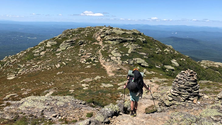
Black Elk Peak, South Dakota
➡️ Length: 7–13 Miles
⏱️ Duration: One day
⛰️ Elevation Profile: You’ll almost always be climbing or descending, but the grades are mostly accommodating.
📍 Best Trailhead to Start From: Sylvan Lake Parking Lot
💛 Why We Love It: In a region rich with geologic oddities, this uplifted zone of ancient granite possibly lets you see into five states.
🥾 For Fans Of: Learning about difficult history, the idea that there’s more to South Dakota than prairie, skipping Mount Rushmore
If you are an enthusiast of the National Park Service, you’ve probably either been to South Dakota’s Black Hills or added it to your must-see docket. It’s home to six NPS sites, including Mount Rushmore, Wind Cave, and Jewel Cave. The first two are truly under-heralded treasures; the less attention the former gets, the better. But if you skip simply because of its lesser designation, you’re getting the passport stamps but missing one of the country’s best expanses of protected land.
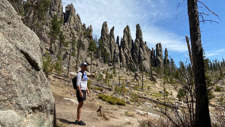
Pristine lakes and idyllic streams, wallowing bison and roaming mountain lions, giant granite spires and a staggering highway: At more than 70,000 acres, Custer State Park could rank as a national park. (I think we could stand to lose the name of a Civil War hero who became a gold-hungry butcher, anyway?) It’s also home to Black Elk Peak, the highest point between the Rocky Mountains one state over and the Pyrenees, one ocean and chunks of two continents away. Far more than a geologic footnote, Black Elk Peak hosts a summit hike that suggests you’re amid an amusement park.
There are a half-dozen ways up Black Elk Peak, via a byzantine network of trails thanks in part to the area’s many managing agencies. The most stunning might be the simplest, too, with an ascent via Sylvan Lake Trail No. 9 and a descent via Little Devil’s Tower No. 4. You’ll work your way through gaps in rock walls, up twisting rock-hewn steps, and over stairwells that feel like Manhattan fire escapes until you reach an architectural marvel of a fire lookout that’s perched atop the mountain like some monstrous castle’s turret. You may believe you’re in a video game.
Named for a Lakota medicine man whose make for indispensable American reading, Black Elk Peak—renamed only in 2016 after commemorating, for more than 150 years, an Army commander who killed Indigenous peoples —is a colossal reminder of our national crimes and the ongoing and necessary quests to correct them. Black Elk Peak is a gateway to the West and questions about it, plus a marvel all its own.
An Easier Alternate: One of my favorite places to swim in South Dakota is Sylvan Lake, where you’ll park to start this hike. If you don’t feel like climbing Black Elk, clamber instead around Sylvan’s rocks.
Coyote Buttes North: The Wave, Arizona
➡️ Length: 6–10 Miles
⏱️ Duration: One day, given you’ve secured a permit
⛰️ Elevation Profile: You’ll feel the steady and occasionally steep climbs on a sunny day, but there’s nothing too crazy here.
📍 Best Trailhead to Start From: Wire Pass Trailhead
💛 Why We Love It: Within a few miles, you can begin to understand the surreal and surprising intricacies that are so abundant in the Southwest.
🥾 For Fans Of: Deep oranges, color-field painting, perfect photos
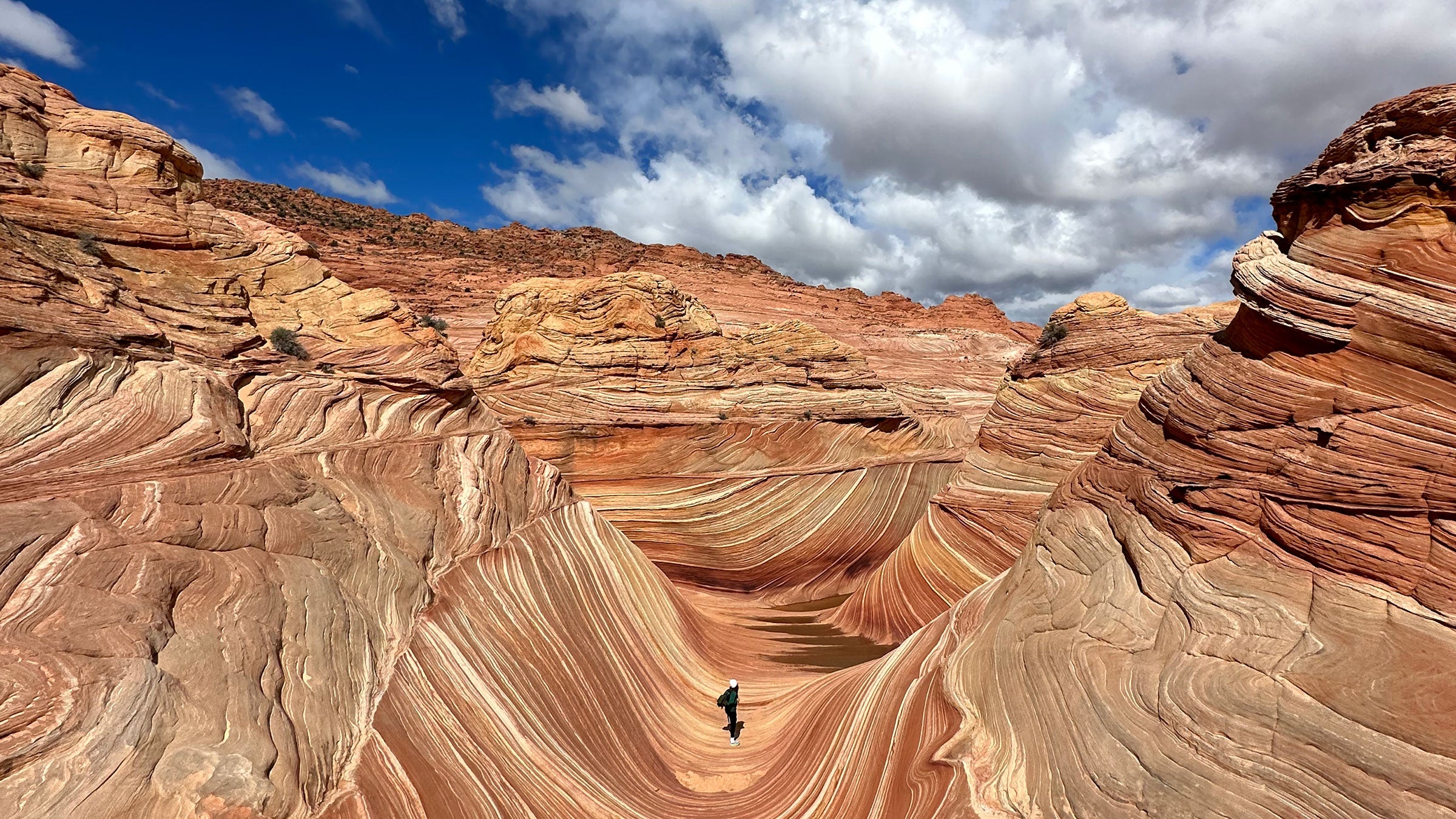
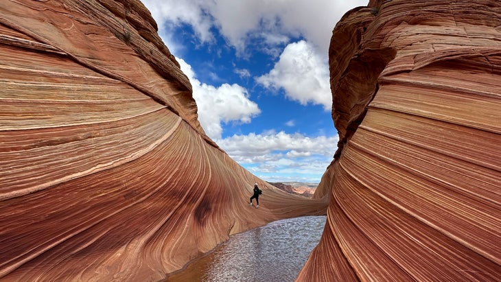
“The Wave is mostly unknown, except to the cowboys running cattle in that area.” So reads the laminated poster in the Kanab Visitor Center at Utah’s southern edge. Though that may sound like some 19th-century fantasy, the sign actually refers to the 1960s, long before one of the world’s most surreal and sublime sections of sandstone also became one of the country’s most in-demand .
In the decades that followed, guidebooks, foreign documentaries, the 2002 Olympics, and, of course, social media created repeated surges of attention for a pocket of wind-eroded buttes so perfectly contoured and colored they look computer-generated. Four dozen people are now allowed to see The Wave per day, six times the quota when the Bureau of Land Management began issuing permits in the ’80s. I have friends who have applied every month for years to “Coyote Buttes North,” as the zone is called, and they’ve still never seen their dream. I’ve been close, but I haven’t marveled at the masterpiece yet either.
It is tempting, of course, to lampoon fever for The Wave, to see the hubbub as some artificial creation of influencer culture. But in nine relatively easy miles, you can sample the wonders of the Southwest without worry about massive crowds. After moving through an emblematic desert wash, for instance, you cross the pristine tracks of Sauropodomorph dinosaurs (and a tail drag)—“a dinosaur dance floor,” a once called it.
Continue past The Wave, and you’ll find windows around the Melody Arch and a great recessed amphitheater positioned among massive dunes, dubbed The Alcove. In a region so rich with geologic miracles, social media obsession with The Wave may indeed seem myopic, but, permits notwithstanding, it may be the most instant portal to seeking out those other sights for yourself in years to come.
An Easier Alternate: The barrier to The Wave isn’t physical; it’s getting a permit. Space is almost always available in the neighboring zone, Coyote Buttes South, which is nearly as striking as the social media star next door.
The First 30 Miles of the Florida Trail, Florida
➡️ Length: 30.6 Miles
⏱️ Duration: 2–3 Days
⛰️ Elevation Profile: It’s southern Florida, as flat as a flounder
📍 Best Trailhead to Start From: Oasis Visitor Center, Big Cypress National Preserve
💛 Why We Love It: This adventure will be the stuff of your dreams forever, from nightmares spent escaping an alligator underwater to fantasies where you remember the glory of reaching the interstate and finding a shower.
🥾 For Fans Of: Flirting with mortality, asking yourself “What the hell, man?,” grinning like a goof
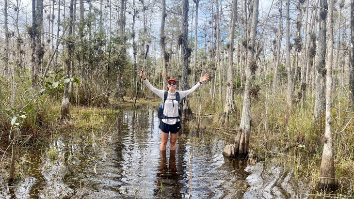
Very few people believe me when I insist, so I’ll just tell you the truth here as plainly as possible: There are few stretches of trail more gorgeous, mysterious, and outright fun in the U.S. than the southernmost 30 miles of the Florida Trail. That span begins at the Oasis Visitor Center in Big Cypress National Preserve, a 700,000-acre expanse of perpetually murky swamps, enchanting pine glades, and prairies that suggest some sunken-world version of Kansas. It ends as you cross the east-west portion of Interstate 75, so notorious for its wildlife that it’s long been dubbed Alligator Alley.
And yes, that means the first 30 miles of the Florida Trail are full of alligators and water moccasins, softshell turtles and frogs so tiny they look like leaves. If you’re lucky, as I was when I hiked it in the early winter of 2022, you might encounter the long-endangered Florida panther or the invasive Burmese python. I almost forgot to mention that these could all be in or around the brown water through which you will walk.
I get it if you’re terrified, but hang on. As you wade through the swamps of southern Florida following orange blazes that mark the trail markers painted on any available dry surface, you will also be surrounded by wild orchids and air plants so thick you will sometimes need to push them out of the way. They seem to sprout out of the trees themselves, less like epiphytes than some novel chimera. It appears as a flooded Eden.
From time to time, though, you will have the surreal experience of swearing there is a little mountain on the horizon, though this is pancake-flat Florida. It is an oasis, an allusion: Those are cypress domes, rounded mounds of trees that are tallest toward the center, where the water is deepest and where camping doesn’t actually exist. Instead, rest for the night in a hardwood hammock, a stand of trees just above the water line that is, in essence, a tropical forest teeming with life. These 30 miles reinvent ideas not only of what hiking can be but where beauty can exist. Just look out for eyes of alligators and big cats, in or around the water.
An Easier Alternate: Want to see the Florida wildlife without walking in the same water they swim? Head to the Royal Palm Visitor Center in Everglades National Park for the and trails, brief primers on how much Florida fun you can have.
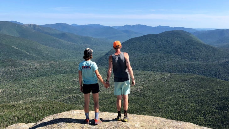
Franconia Ridge Loop, New Hampshire
➡️ Length: 9 Miles
⏱️ Duration: A half-day
⛰️ Elevation Profile: You’ll have a steep climb followed by a merciful rolling ridge walk and then a big drop back down.
📍 Best Trailhead to Start From: Lafayette Place Campground, Franconia Notch State Park
💛 Why We Love It: This is a welcoming introduction to mountain climbing, to reaching a summit ridge (and some peaks, too), and feeling like the whole world unfurls before you.
🥾 For Fans Of: The vague suggestion of danger, the satisfaction of summits, the company of strangers
The axiom of outdoor adventure travel is that it makes us feel small, that it transports us beyond the egotism of our own daily concerns if only for one out-of-body instant. But this happens because, in those moments, we understand just how vast our surroundings are, just how unknowable it all is to us and how unknown our concerns are to it. This sensation is the manna of mountain climbing, a reason that so many of us return to peaks so high and massive the world seems infinite.
There are few places more magical and convenient when it comes to that feeling than New Hampshire’s Franconia Ridge, a thin but very manageable air-bound isthmus of land between a half-dozen 100-million-year-old peaks. Standing on the two-mile runway between Lafayette and Little Haystack, you are three hours from Montreal and two hours from Boston or the New Hampshire coast. From up there, though, the entire world seems like a mountain range, as rich with beauty as the seasonal green or white on each peak’s flanks.
It is no surprise, then, that the loop that climbs to and descends from Franconia Ridge is one of the country’s most popular hikes. Arduous without being technical or terrifying, this trek squeezes a lot of diversity into just nine miles, from the climb through thick forests (where stands of maples and birch give way to spruce and fir) and past one of the White Mountains’ iconic to its descent alongside rushing waterfalls.
But it hinges on the phenomenon of being surrounded by nothing (so much sky!) and everything (so many peaks!) at once that you get after reaching Mount Lafayette’s 5,260-foot summit, then walking through a rare Eastern stretch of alpine tundra. By Colorado’s standards, for instance, that’s much lower than a trailhead for a climb. But in New Hampshire, because of the high latitude and the proximity to coastal weather, it is an accessible taste of how humbling and galvanizing high mountains can be. Caveat emptor: I got addicted to that rush somewhere around there, so proceed with caution.
An Easier Alternate: Seen those “This Car Climbed Mount Washington” bumper stickers? If you’re not feeling a hike, take the scenic Auto Road to its top, but give yourself time to wander around this landmark Eastern summit.
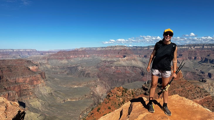
The Grand Canyon: Rim-to-Rim, Arizona
➡️ Length: 20–30 Miles
⏱️ Duration: 1–3 Days
⛰️ Elevation Profile: Hey, at least the several thousand feet of downhill and uphill on either side are broken up by a nice canyon stroll.
📍 Best Trailhead to Start From: North Kaibab Trailhead, so you can indulge in burgers and beer on the South Rim when you’re done.
💛 Why We Love It: Not only will it be a feat of personal endurance, but it will also change your perception about how dynamic time and space can feel.
🥾 For Fans Of: T-shirts that commemorate lifetime achievements, bragging rights at parties, very steep but slow roller coasters
A true story: Less than a decade ago, on a free trip to Sedona, my wife, Tina, and I took a last-minute drive at dawn to the South Rim of the Grand Canyon. It was socked in with clouds, so we dropped briefly beneath the rim on South Kaibab Trail, long enough for us both to gaze into what seemed infinite folds of red rock. Two months later, we’d quit our jobs, sold our house, put everything in storage, and moved into a van. That moment with the Grand Canyon turned us into van-dwelling, mountain-climbing thru-hikers, and I’m eternally grateful for that vista. We’ve since crisscrossed the Grand Canyon multiple times; the scale of its wonder only ever increases.
Hiking between the Grand Canyon’s rims opens your mind and rearranges the furniture inside. Intellectually, you confront the reality of deep time, as you move down, along, and up two-billion years of geologic history; to witness the is to understand the pull of mystery, of the unknown. Aesthetically, you are walking in an art installation so vast it is not yet entirely understood and so enchanting we have yet to stop trying; it is like seeing a new detail in your favorite painting, except the canvas has no end, or at least one you cannot see.
And physically, you are moving across a marvel of our world, a gap so big it can be seen from space; to finish it is to realize just how much you can do, even if it’s over the course of several days. In fact, slow down as much as you can, since you could spend a lifetime looking and never be satisfied here.
An Easier Alternate: If you’re short on time or worried that your knees aren’t ready for the rim-to-rim gauntlet, drop from the South Rim to , where, yes, you will probably say that.
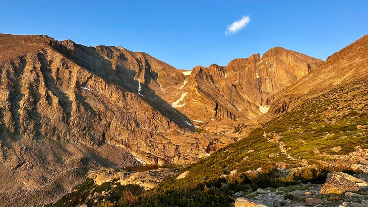
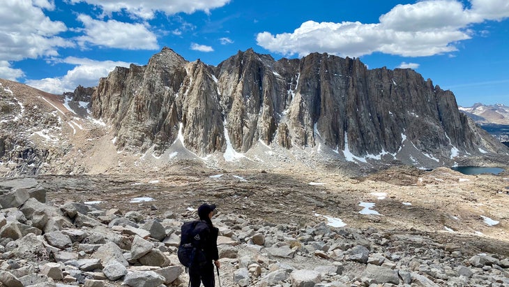
Longs Peak: The Keyhole, Colorado
➡️ Length: 14 miles
⏱️ Duration: One day
⛰️ Elevation Profile: You’re here to go up a legitimately big mountain, so it can get intense.
📍 Best Trailhead to Start From: Longs Peak Trailhead
💛 Why We Love It: Though it should not be your first of Colorado’s 58 14ers, it could well be the one that introduces you to mountain climbing that involves gumption and the thrill of encountering your mortality.
🥾 For Fans Of: Geologic features with evocative names, bursts of adrenaline, big pizza rewards
In the continental U.S., just surpass 14,000 feet, the threshold required for that celebrated category of “14ers.” Three-quarters of them are in Colorado, topping out at 14,438 with the gentle slopes of Mount Elbert. Most of these peaks are deep in Colorado, far from the shopping centers and urban bustle of the Front Range. But not Longs: On a bluebird day, Longs and its mammoth neighbor, Meeker, can be seen from Denver. They make better bulwarks of the Colorado skyline than the city’s tallest buildings.
Longs happens to be one of the country’s , too, from the Salvador Dalí-like towers of its Keyboard of the Winds and an imposing face dubbed ‘The Diamond’ to the massive “Notch” that makes it identifiable from many miles away. It is a showcase of geologic forces, a marvel of strange geometry.
And it is entirely , even if you’re rather new to the state sport of 14ers. (But please do not head straight from the airport to climb Longs. Acclimate, and maybe hike a 14er like Quandary first.) Every year, an estimated 15,000 people attempt to climb Longs, the highest point in Rocky Mountain National Park and one of the few places in the park that requires neither a permit nor a fee. Most of the climb is a splendid hike, first through a forest so fragrant it feels as if you’re walking through a candle shop and then across rocky slopes and boulder fields that conjure jungle gyms. (You should start early enough that Boulder’s lights twinkle behind you.)
The fun—and, yes, the danger—start when you cross through the famous Keyhole, following a series of painted bullseyes through the vertiginous Trough and the aptly named Narrows. From the summit, the kingdom of the Front Range is in view, from the Wild Basin below to the Indian Peaks beyond. This is one of the most marvelous places in the U.S. to spend your morning.
An Easier Alternate: If the first four miles and 2,000 feet of the climb up Longs Peak drain you (or if it’s long past sunrise, honestly), stop. Go instead to , the jewel at the base of Long Peak’s gargantuan wall, The Diamond. You won’t be disappointed.
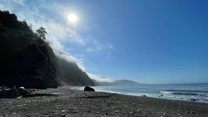
Lost Coast Trail, California
➡️ Length: 25 Miles
⏱️ Duration: 2–4 Days
⛰️ Elevation Profile: You’ll see steep terrain nearby, but you won’t be climbing too much of it. This is mostly gentle.
📍 Best Trailhead to Start From: Mattole Beach Campground
💛 Why We Love It: In California, some of the country’s best nature has been bent to society’s will; here, engineers just gave up.
🥾 For Fans Of: Salt spray kisses, black sand beaches, elephant seal calls
Tell someone you are going to hike on the California coastline, and they’ll likely be confused, picturing beach-ready bodies bounding in and out of the surf as you stroll awkwardly by wearing a backpack. But California’s premier coastal hiking—and, really, one of the best stretches for breathtaking beach walking in the U.S.—is in northern California, in a region so remote and rugged that highway engineers simply gave up on trying to route roads through it: the Lost Coast.
For backpackers, that engineering abdication has been a boon, leading to a 25-mile span of undeveloped beachfront where black bears roam, elephant seals cavort, and tides lash against cliffs and coves with might. This is the Lost Coast Trail, one of the last secluded and most untrammeled places in a state of development dreams.
Only a few miles inland from this gnarled shoreline, King Peak rises almost to 4,100 feet, an impressive height considering the nearby Pacific. In fact, the surrounding is not far from the Mendocino Triple Junction, an offshore intersection of tectonic plates and intense geologic activity that led to the land’s sudden rise from the sea. The Lost Coast Trail moves back and forth from the beaches to the quickly rising shore above it.
Several sections of the hike cling so closely to the walls above that you can pass only when the tide is low, making these miles more about planning than perseverance. Oh, and you’ll need a , too, since the Bureau of Land Management rightfully wants to keep the Lost Coast … well, not entirely lost, but at least much less crowded than its counterparts to the south.
An Easier Alternate: If you’re worried about navigating the tides, you can stick to the trail’s middle section only between Sea Lion Gulch and Miller Flat by starting at Kinsey Ridge Trailhead.
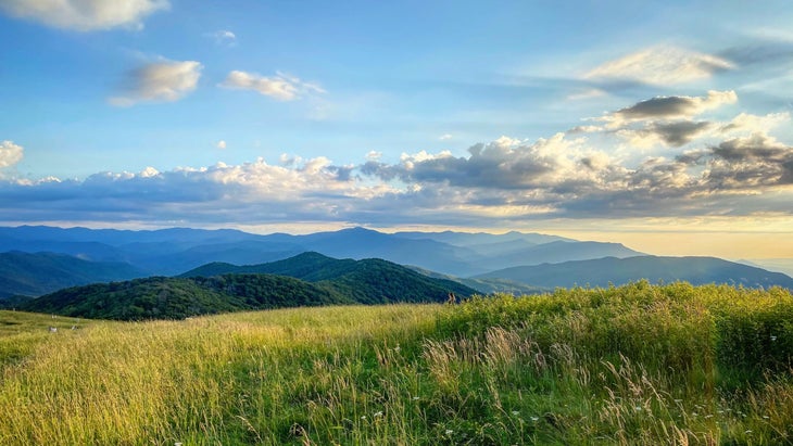
Max Patch, North Carolina
➡️ Length: 1.5 miles
⏱️ Duration: 1 Hour
⛰️ Elevation Profile: You’ll likely stroll right up it, even the few bits that seem steep.
📍 Best Trailhead to Start From: Max Patch Road
💛 Why We Love It: The shortest walk here offers one of the grandest glimpses of Appalachia anywhere.
🥾 For Fans Of: Little walks to big views, jokes about Bill Bryson’s A Walk in the Woods, lessons in crowd control
There is a strange phenomenon in Southern Appalachia, where both the mountains and the latitude are so low that even the highest peaks, like Mount Mitchell and Clingmans Dome, can sustain trees. But a series of so-called “balds” do not, their rounded tops given over to mountain oat grass and diminutive flowering plants.
There are a half-dozen for why this happens, and balds generally come in two categories—cultural, meaning they were once cleared by people, and ecological, meaning it’s simply nature at work. In either case, balds often offer panoramic views of the surrounding Blue Ridge Mountains and Roan Highlands, some of the most pastoral and pleasant ridgelines in North America at any height or distance.
About 250 miles northbound on the Appalachian Trail, Max Patch may be the best; a little loop hike from an oft-overrun parking lot, it is certainly the most accessible. Cleared for grazing long ago, Max Patch is particularly broad, its viewshed letting one peer one way into nearby Tennessee and the squiggles of the ancient French Broad River and the other way to some of the East’s tallest points.
I hesitate to put Max Patch, once practically my backyard, here, because it has been so overrun by revelers in recent years that the National Forest Service has . But the ecosystem has started to recover, a testimonial to good management of places whose demand speaks to their majesty. Go to Max Patch. Marvel at the uninterrupted views. And then leave it for the next person, please.
A Harder Alternate: If you want to experience the sylvan charm of the AT and endure its chronic ups and downs, have someone drop you at Max Patch for the 20-mile trek into Hot Springs, North Carolina. You’ll drop into several gaps and cross gentle Bluff Mountain along the way.
Pacific Crest Trail, California, Oregon, and Washington
➡️ Length: 2,655 Miles
⏱️ Duration: 3–6 Months
⛰️ Elevation Profile: You will be surprised by how rarely daunting the PCT is as it rolls from one border to the other.
📍 Best Trailhead to Start From: Southern Terminus, Campo, CA.
💛 Why We Love It: Of the country’s three iconic long trails, its reward-to-work ratio is by far the highest, with each day looking like another stunning photo ripped from the pages of a National Geographic calendar
🥾 For Fans Of: Looking at your Apple Desktop photos, pretending to be Ansel Adams, putting your life on hold
To call a 2,600-mile, multi-month journey between the borders of the U.S. one of its most beautiful hikes is a cheat, I know; such an endeavor at least seems impossible to many for reasons of practicality and privilege. But mile for mile, no long-distance hike in the nation is easier or more visually rewarding than the Pacific Crest Trail.
For that first compliment, remember that the PCT is so long because its grades are so slight, meaning that you wind around canyons and peaks rather than shoot straight up or into them, as on the Appalachian or Continental Divide trails. If you can walk at a reasonable pace, you can finish the PCT. And especially if you’re headed north, 700 miles of desert (and the occasional mountain) will prepare you for the more daunting stretch that is the Sierra Nevada.
Speaking of the Sierra Nevada, it is the rare mountain range to combine relatively easy hiking, very high elevations, and completely spellbinding sights. To move between the high passes and among the glacial lakes and verdant glades of the Sierra is to be dumbstruck by the same landscape that catalyzed U.S. conservation. This goes for the entire PCT, really, where almost every day feels like you’re walking through a screensaver or a wall calendar.
The Goat Rocks Wilderness and Mount Rainier views in Washington? The Three Sisters and Crater Lakes zones of Oregon? Almost the entirety of California, from the reaches of San Jacinto to Shasta? It’s a stunning journey, the long trail you should do if you have one in you.
An Easier Alternate: Though it’s no piece of cake itself, California’s High Sierra Trail offers a relatively short but incredibly scenic route through the mountain range that is the PCT’s crux.
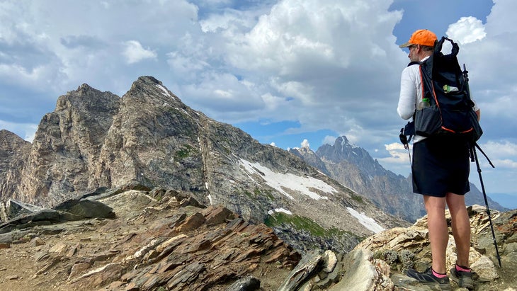
Teton Crest Trail, Wyoming
➡️ Length: 35–40 Miles
⏱️ Duration: 2–4 Days
⛰️ Elevation Profile: You’ll encounter occasionally steep climbs out of basins and over passes, but this one is often cruisey.
📍 Best Trailhead to Start From: Phillips Bench Trailhead
💛 Why We Love It: With both an airport and a great mountain town nearby, there may be no better or more accessible way to understand the immersive splendor of the country’s most distinctive peaks.
🥾 For Fans Of: Mountains that are sculptural masterpieces, carrying bear spray on your hip, marveling at wildflowers
Since my first climb in Grand Teton National Park nearly a decade ago, I have returned every year for new mountains and fresh hikes with a fanatic’s devotion, as if this were my annual pilgrimage. Still, after all that time, I feel like I haven’t even started to understand the bounty of the place, the marvels it hides in the folds of its mountains or the basins and ridges between them. I often ask myself if, even after a lifetime of visiting, I will still feel the same way about my favorite bit of land in the U.S.? I’m intent on finding out.
There may be no better sampler of the place than the Teton Crest Trail, a masterpiece of a route that winds between the park itself and the Bridger-Teton National Forest. It’s a , which is for the best: You want to have the occasional sense that you have this landscape all to yourself. You’ll probably find yourself longing to return, too.
Despite its name, the Teton Crest doesn’t simply stay high, and you don’t really near the summits of the . Instead, you often stick close to the park’s myriad lakes—Phelps, Marion, Sunset, and so on—and cling to elaborately shaped shelves just above deep canyons. You’ll cruise through Alaska Basin wide-open expanse and many alpine meadows, then climb atop Paintbrush Divide, the trail’s highest point, for gobsmacking views of the Tetons.
It’s not all geology, either, since Wyoming wildflowers are some of the best in the West, clusters of purple and yellow, red and white pushing up from endless seas of bright green grasses. Moose, deer, elk, and, yes, brown and black bears roam the same trail. Few places in the U.S. proclaim the marvels of wilderness more loudly than this grand bit of western Wyoming; this is your avenue to listen and see.
An Easier Alternate: If you want to understand what it’s like to climb at the edge of the Tetons without spending days among them, the uphill haul to gets you closer to them after a five-mile spiral among wildflowers and forests.
Grayson Haver Currin is �����ԹϺ���’s hiking columnist and a Triple Crowner. He has logged over 10,000 miles on the U.S.’s National Scenic Trails and countless more on other trails. A North Carolinian who moved into a van with cats, a dog, and his wife, Tina, in 2017, he now lives high among the mountains of Colorado’s Front Range. He is also a music journalist for The New York Times, Pitchfork, NPR, Mojo, GQ, and others, and you can subscribe to his forthcoming newsletter, Out and Back, .