

The 5 Best Hill Climbs in North America
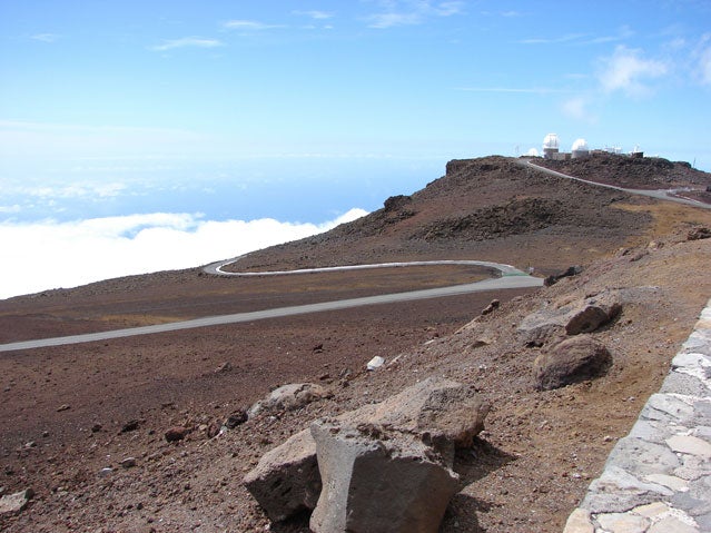
Last year, I went to Maui seeking tropical repose but ended up logging the ride of a lifetime. Friends said that just proves how overwhelming my addiction to cycling is, but the real culprit is the island’s formidable network of roads. The queen is Crater Road, which switchbacks through half a dozen eco-zones on its way from seaside to Mt. Haleakala’s rubbly, 10,023-foot summit. The road is broad and smooth and never steep, so you can spin along and watch banks of clouds unfurl over the Pacific. By my numbers: 90 miles, 10,794 feet elevation gain, 3.5 hours climbing. My wife, who went to the beach instead, just shook her head at me when I finished.
Complete Guide to Climbing
 The Complete Guide to Climbing
The ride got me wondering about other iconic hill climbs in North America. Of course I know the famous ones—14,240-foot , New Hampshire’s , SoCal’s —but I wanted to find others. So I called John Summerson, author of . Summerson’s book catalogs 144 road climbs in North America (“I’ve ridden 99 percent of them.”), and he’s working on an expanded second edition. “The more of these climbs you ride, the more you want to find,” he told me. “It’s the combination of difficulty, scenery, grade, and climbing history that draws you in.”
When I asked him for his five favorite climbs, his response showed me just how passionate he is about hill climbs. “Just five?” he asked with real agony in his voice. “That’s like putting a gun to my head. People think we don’t have climbs as good as Europe in the US, but they just don’t know where to look.”
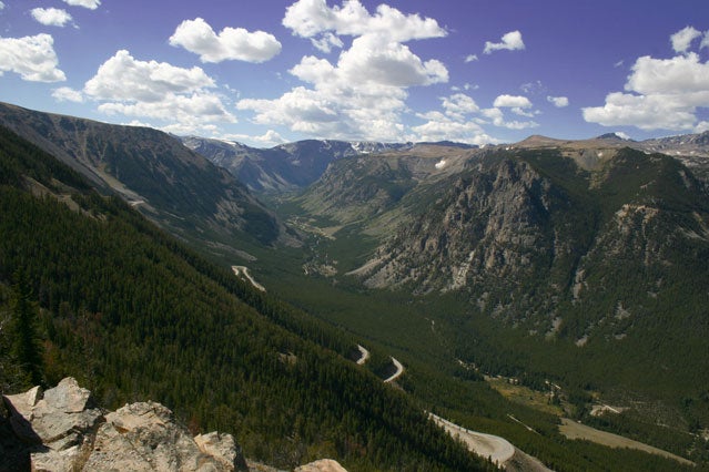
Beartooth Pass North, Montana
Best for: Endurance Junkies
Start: 5,675 feet
Finish: 10,947 feet
Length: 30.4 miles
Total Elevation: 5,272 feet
Rating: Cat. 1
The north side of Beartooth Pass is a long climb into the Beartooth Mountains in southern Montana that finishes in Wyoming. It is never very steep but contains amazing views down into the valley as you ascend multiple switchbacks. At mile 22 the climb pops out above tree line and heads across spectacular alpine terrain. At mile 27 there is a descent before the final push up to the pass.
Summerson says: “This is probably the least difficult of the five. It’s very shallow, with an average grade of 3.3 percent. The whole time you’re wondering why and how they managed to jam a road over it. Good thing they did.”
Logistics: The climb begins in Red Lodge, Montana, where the historic (from $75 a night) is a great base for operations. Head west on Route 212 from the junction of Routes 212 and 308.
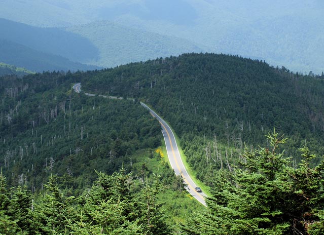
Mt. Mitchell, North Carolina
Best for: Scenic Views
Start: 1,425 feet
Finish: 6,586 feet
Length: 24.1 miles
Total Elevation: 5,161 feet
Rating: Cat. 1
Mount Mitchell has one of the greatest elevation gains of any climb in the United States, and the climbing styles are very diverse. The first section (Route 80) starts out shallow but gradually gets steeper as you ride. Its top portion contains a series of 180-degree switchbacks as it nears the . After several tunnels and a descent, the climb resumes on Mount Mitchell State Park Road, which is a bit steeper than earlier climbing. The dead-end road is the highest legal paved road in the eastern US.
Summerson says: “The tunnels can be irritating because they’re quite dark. This one’s close to my home, though I tend to prefer shorter, steeper, knee-breaking types of climbs. But this one sure is scenic. And the humidity makes it even harder.”
Logistics: From the small town of Marion, at the junction of Routes 221 and 70, head south on Route 70. In around two miles turn right on Route 80. After 2.8 miles you come to the Lake Tohoma dam, which you circle before crossing a small bridge over the creek that feeds the lake. This is the start. As a feeder town for the Blue Ridge Parkway, Marion has plenty of hotels, but the (from $105 a night) in nearby Morganton is a big, rambling B&B that’s worth the drive.
Onion Valley Road, California
Best for: Punishment
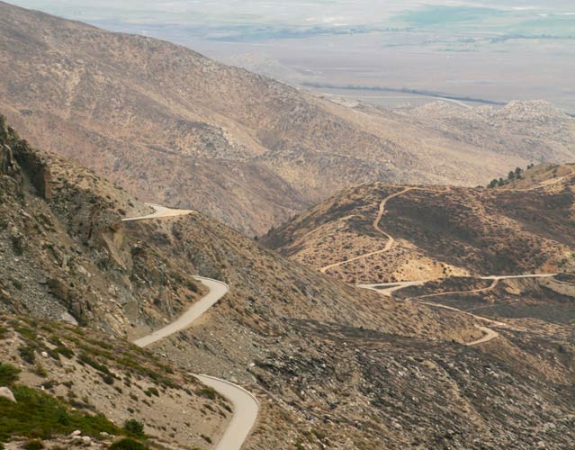
Start: 3,994 feet
Finish: 9,163 feet
Length: 12.5 miles
Total Elevation: 5,169 feet
Rating: Hors Catégorie (Beyond Categorization)
, in the Eastern Sierra, is perhaps the most difficult climb in California and among the most spectacular in the world. It is steeper and longer than both the Tourmalet and the Galibier, two iconic climbs of the Tour de France. Enjoy the first few miles. They are about the only break you will get on this hill. The grade ramps up as you ascend, with the last ten miles averaging over 8 percent. There are lots of switchbacks, and a dramatic section of them about halfway up the climb is the highlight, as it offers huge exposure and views over the Owens Valley. The torturously twisting descent is hair-raising and perhaps the top overall downhill in the United States.
Summerson says: “Probably my favorite climb of all. It’s just stupendous! Onion Valley is one of those rare hills where you may rue the end of climbing.”
Logistics: From Highway 395 in Independence, California, turn west on Market Street. The climb starts 0.4 miles down this road (which becomes Onion Valley Road) at the cattle guard. There’s not too much in Independence, but the town of Bishop, 40-some miles north, is the jumping off point for lots of adventuring (, Buttermilk Boulders). Try the (from $90 a night), an 1898 home that’s been fully restored into a B&B.
Wheeler Peak, Nevada
Best for: Isolation
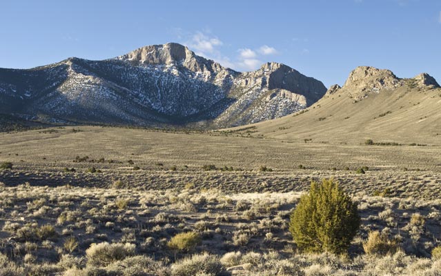
Start: 5,318 feet
Finish: 10,163 feet
Length: 15.6 miles
Total Elevation: 4,845 feet
Rating: Cat. 1
One of the most difficult climbs in Nevada, Wheeler is a lonely climb near the state’s eastern border that few people know about. It is significantly longer and as steep as one route up the Col d’Izoard, a beyond category climb often used in the Tour. A very straight and steady-grade greets you at the base of this isolated hill, with great views of usually snow-capped Wheeler Peak in Great Basin National Park. After turning right on Wheeler Peak Scenic Drive (continue straight to get to the National Park Visitors Center), the road is narrow and twisty and wends through stands of trees. The climb ends at Summit Trailhead (10,163 feet), with the massive mountain right in front of you. The paved road continues but descends down to a campground.
Summerson says: “This island peak is almost always snow-capped. You climb from the desert to the high alpine. I don’t think I’ve ever seen another cyclists on Wheeler.”
Logistics: Part of this climb’s appeal is its remoteness. There are a few little motels and diners in Baker that feed ($6 a night to camp) but it’s the sort of place you figure out once you roll in. From town, take Route 487 to the junction with Route 488, where the climb begins by heading toward the park.
Whiteface Mountain, New York
Best For: Quick Night Cap
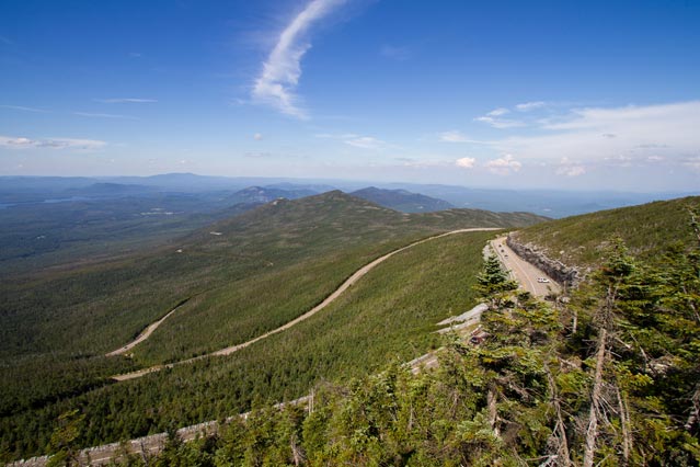
Start: 1,040 feet
Finish: 4,606 feet
Length: 7.9 miles
Total Elevation: 3,566 feet
Rating: Cat. 1
Located in the Adirondacks of up-state New York, this climb is almost identical in length and grade to l’Alpe d’Huez, considered one of the most difficult climbs of the Tour de France. It is closed to bikes until 5 p.m., so plan an hour and a half to tackle it (though the record stands at 43 minutes). The grade is sturdy right from the start, so a warm up is probably a good idea. After three miles and a toll booth, the grade averages ten percent for three miles. Closer to the summit, the slope finally eases, the trees clear, and views begin to appear. A few large and graceful turns lead you higher on the mountain over moderate grade. The climb ends where the road dead-ends at the upper end of the parking lot, from where you can hike or take an elevator to the very top of the mountain. The visitor’s center is in Whiteface Castle, at the peak’s crest, where you can see all the way to Vermont and Canada on clear days. Whiteface is also one of the fastest descents in the U.S., and there is an annual race down its slopes.
Summerson says: “I got interested in Whiteface once I realized that it is almost identical to Alpe d’Huez. I’ve ridden it three times since. That’s part of the fun of doing these climbs: finding out how our climbs and numbers compare to the big ones we always see in Europe. Don’t underestimate Whiteface because of the short distance. It is hard.”
Logistics: Host to the alpine skiing events in the , Whiteface Mountain, and the town of Lake Placid to the south, have a healthy tourist infrastructure. The sprawling wood and stone (from $350 a night) is one of the most beautiful spots to stay in the area. In Wilmington, NY the climb begins at the junction of Routes 86 and 431 by heading up 431.