Not many people in the United States know much about . It’s a sliver of a country tucked into the northwestern rump of the continent of Africa. It cuts into Senegal at the Atlantic coast and runs roughly 310 miles long and 31 miles wide on average. Along its length, the Gambian River separates it like a knife through a sheath.
People may not have heard of The Gambia for many reasons. It’s one of the smallest countries by area in Africa, and home to just 1.8 million people. There are few negative headlines about the country. After a bloodless coup in 1994, there has been little breaking news to feature on any front page. Life is slow, and often hard. More than 75 percent of the population relies on agriculture for their livelihood. Peanut production, fishing, and tanning are some of the main industries. There is tourism, but most of the visitors come from Europe and don’t venture inland, preferring to sun themselves along the 49-mile-long coast. The United States has placed 100 Peace Corps volunteers in the country for short stints, and they often return to share stories with families and friends, but otherwise, it exists off the radar.
Jason Florio, Alkalo Dadi Bah, Helen Jones-Florio. Photo: Jason Florio
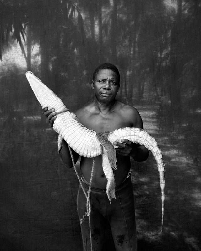
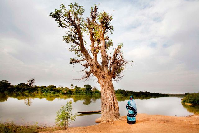
Jason and Helen Jones-Florio are working to expose more people to The Gambia. The British-born, New York City-based photography duo has been traveling to the country for more than 15 years. Jason first photographed the country in 1996 when a couple of friends asked him to visit an ecotourism project they had started in a 250-acre area of bush known as . He slept in a hammock, met individuals in their villages and in the bush, set up a simple black mesh backdrop behind them, and took their portraits, with little in the way of spoken communication. Though more than 90 percent of the population is Muslim, there are more than eight ethnic groups. Many of the people from these different groups intermarry, and, as a result, there is a high level of peace among a variety of people, Florio says. There is also an interesting mix of individuals for a portrait series. In 1998, Jason met Helen in the country. In 2008, they started a relationship and began traveling to The Gambia together. The Florios continue to return to meet the people at their level and quietly take their portraits. In so doing, they've created a record of a country that might otherwise be ignored.
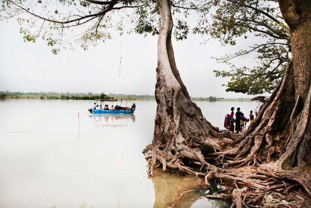
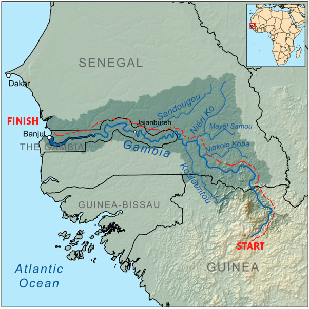
They've done all of this through a series of adventures. The couple’s last major trip to the country was a 577-mile circumnavigation on foot in 2009. Jason took pictures of local chiefs for a series, “,” that won first prize in The International Photography Awards of 2010. A week into that trip, they planned for something more, to retrace Scottish explorer ’s 18th-century footsteps from The Gambia to what is now Mali (““) and back. With recent insurrection brewing in Mali, and a host of kidnappings, they abandoned that plan and drew up a new one: to paddle the the River Gambia from source to sea. This October, as the rainy season winds down, Jason and Helen will canoe and hike roughly 700 miles—from the source of the river in the Fouta Djallon highlands of Guinea, through the hippo-infested in Senegal, and along the river as it splits The Gambia until it empties into the Atlantic at a six-mile-wide mouth. I checked in with the duo via email for more on the expedition.
Map of the River Gambia. Illustration: Jason Florio and Helen Jones-Florio
Why do this trip?
We poured over incredible logs of journeys at the in London—of explorers traveling up the River Gambia from the Atlantic Ocean back in the 1600s, with most not being able to penetrate more than 600 km (373 miles) up stream—but we couldn’t find any accounts of anyone following it from source to sea, by canoeing and hiking. We vainly liked the idea of doing something we could find no record of having been done before. Having said that, the journey is not about making what we think is ‘a first’ as, no doubt, some Aussie will come out the woodwork, post expedition, to nonchalantly say “Mate, I did that river on a standup paddleboard back in ’69!” The journey is more about creating a modern-day account of the people, societies, and life along the length of one of Africa’s last, free-flowing, major rivers—perhaps not too dissimilar to what Mungo Park did at the end of the 1700s. We’ll just be using more modern technology, as opposed to notes stuffed inside a top hat and a couple of fowling pistols for protection.
Why do this trip only by canoe and on foot?
The idea is to go slow and soak in the environment and cultures, taking in the nuances of the micro view you get when walking and paddling. Being in a car, at any stage, would remove us from this experience. Arriving by canoe, or on foot, into a remote village, we feel, is much less threatening. When we walked around The Gambia it made it much easier to connect to people. We approached each other from the same level, literally and figuratively, and not by emerging out of a puff of cool AC from a fat Land Cruiser.
On a practical level, we would not be able to reach many of the areas we intend to travel through by car. We’ll be using folding canoes, which can be more readily portaged as opposed to rigid motorboats. Keeping the journey simple is essential.
What will be the toughest part?
There is a 200km (124 mile) section through the , a 9,130 square km (3,525 square mile) national park in Southern Senegal, that will be the most remote and the most hippo-infested part of our journey. (There are an estimated 6,000 hippos in this small section of the park.) Back in the 1970s, UNESCO removed all the villages from the park, with the aim to protect it. But the consensus is that this has led to its demise. With just a few park rangers to protect the animals, the place is now rife with poachers. So, we’ll have to take an armed guard with us on that part of the river. There is a slight irony to this as the park is known for its array of potentially dangerous wildlife—elephants, lions, leopards, baboons, hippos, and crocodiles—yet we need a man with an AK-47 to protect us against humans.
You mention on the website there may be a dam?
The proposed will be located 930 kilometers (577 miles) upstream on the Senegal/Guinea border. Studies have been going on for almost 10 years, but funding issues and political unrest in Guinea have prevented breaking ground. But attendees at a conference in Dakar a year ago agreed to accelerate the project with potential funding from China and India. Although bringing much needed light to one of the darkest continents on the planet may be a positive move, the impact to the biodiversity along the river, scientists say, will be immense. For example, in the Niokoloa Koba National Park, already a fragile UNESCO site, changing the river’s eco-system in this reserve will have a massively negative effect on many of the creatures, such as the hippos and crocodiles whose survival depends on the seasonal, natural fluctuations in the river level. Not to mention the displacement of thousands of people—communities who live in the areas which the dam will flood.
What kind of stories are you looking to tell?
The journey becomes its own once we touch down. The preconceived ideas we had for photographs and stories as we sat in our apartment in NYC, or as we prepared for the journey whilst based in the U.K. will no doubt change and/or seem completely irrelevant as the journey unfolds. The basic fundamental thread for the work is to tell the stories of those people who live and work along the river’s course.
What do you hope the end result of the expedition will be?
We could get all hippy here and talk about personal realizations and enlightenment, but we hope the result of the project will be to create a body, or bodies, of work (visual, audio, and written) that can be used to share our experiences and introduce people to a region, the people, and cultures that they may not otherwise know about. Perhaps we may even inspire them to travel to Africa—just as we were inspired by the writings of Mungo Park, Gaspard Mollien, and other early travelers to the region.
Do you have a main sponsor?
We don’t have a main sponsor. It’s more a collaboration. We have some great : SteriPEN, Yellowbrick, Peli UK, OverBoard, DPx Gear, and Gambia Experience. We also have a where individuals can donate in exchange for post-expedition prints and their name on a banner. The funding enables us to cover the on-the-ground expenses—i.e. paying our local expedition team members, and fixers from each country we travel through, for a period of two to three months.
You can follow the duo's journey on their expedition blog, , and on the Facebook page.
H/T:
—Joe Spring